Explore Arizona with Easy-to-Use Travel Maps
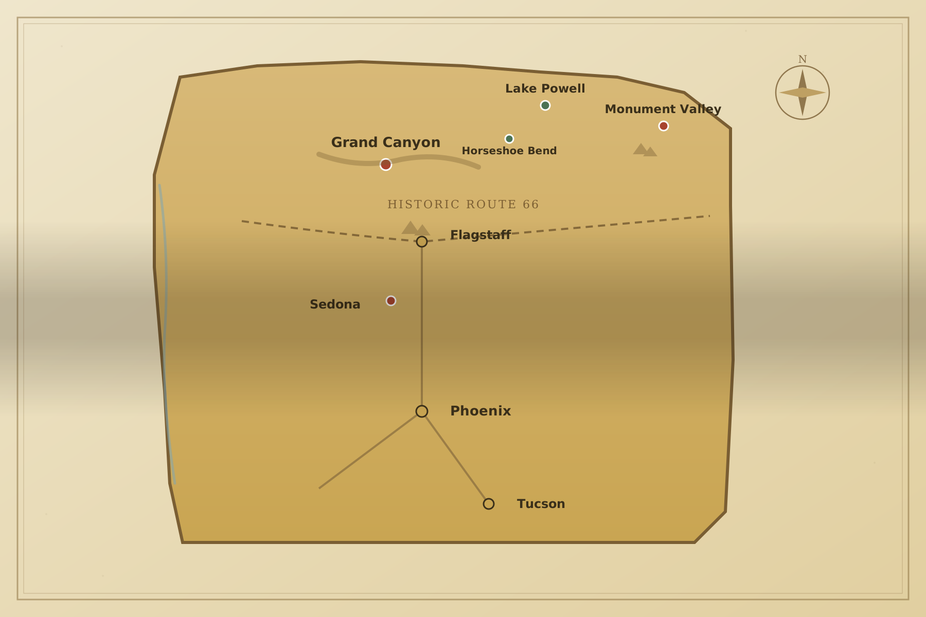
Arizona is much larger than most first-time visitors expect, and understanding its geography is one of the simplest ways to build a smarter itinerary. This page is designed as a navigation hub for exactly that purpose — a set of maps and mapped-out regions covering the state's mountains, deserts, national parks, historic towns, scenic highways, and Native American lands, all in one place.
Rather than a single overview, we've broken Arizona down by theme: cities, national parks, scenic wonders, airports, road trip routes, and climate zones, each with the real distances and driving times you'll actually need. If you'd rather skip the navigating altogether, Grand Canyon Journeys offers private guided tours departing from Sedona, Flagstaff, and Williams for travelers who prefer to leave the driving and planning to experienced local guides.
Arizona State Map
At the highest level, Arizona divides into a handful of distinct regions. The northern third holds the Grand Canyon, the Colorado Plateau, Sedona's red rocks, and the high-elevation pine forests around Flagstaff and Williams. Central Arizona is dominated by the Phoenix metro area and the Sonoran Desert, while southern Arizona brings Tucson, the borderlands, and desert mountain ranges like the Chiricahuas. Western Arizona follows the Colorado River south from Lake Mead through Kingman and Yuma.
Interstates 40, 17, and 10 form the state's main arteries: I-40 runs east-west across the north through Flagstaff and Williams, I-17 connects Phoenix north to Flagstaff, and I-10 runs from California through Phoenix to Tucson and on to New Mexico. Major airports sit at Phoenix, Tucson, and Flagstaff, with smaller regional airports at Page, Sedona, and Prescott. Together, these highways and airports define how nearly every Arizona itinerary gets built.
Arizona Cities Map
Arizona's cities cluster into a few driving regions rather than spreading evenly across the state. In Central Arizona, Phoenix, Scottsdale, Mesa, and Tempe form one contiguous metro area, all within about 30 minutes of each other. Northern Arizona's towns, Sedona, Flagstaff, Williams, and Page, sit closer to the Grand Canyon and to each other, typically 45 minutes to 2.5 hours apart. Prescott, Jerome, and Cottonwood cluster together in the Verde Valley, a short detour south of Sedona.
Tucson anchors Southern Arizona, roughly two hours south of Phoenix, while Kingman and Yuma sit in the state's western reaches, along Route 66 and the lower Colorado River respectively. Knowing which cluster a city belongs to is often more useful for trip planning than its distance from any single reference point.
Arizona Scenic Wonders Map
Arizona's most photographed landscapes cluster heavily in the north, within a few hours of each other. Near Page, Antelope Canyon and Horseshoe Bend sit minutes apart, both within easy reach of Lake Powell's sculpted sandstone shoreline. East of Page, Monument Valley's towering buttes straddle the Utah border, while the Painted Desert stretches along I-40 to the east.
Closer to Flagstaff, Meteor Crater and Grand Falls offer two very different kinds of dramatic, while Oak Creek Canyon connects Flagstaff to Sedona through a forested red rock gorge. Far to the north, Vermilion Cliffs guards the approach to the Utah border, home to the famous Wave formation and Condor release sites. Canyon de Chelly and Utah's Natural Bridges lie just beyond Arizona's own guide pages but round out the Four Corners region for travelers extending their trip.
Arizona Airports Map
Phoenix Sky Harbor is Arizona's busiest airport by far, offering the widest selection of flights and rental cars, followed by Phoenix-Mesa Gateway as a smaller alternative for the East Valley. Flagstaff Pulliam is the closest commercial airport to the Grand Canyon and Sedona, while Tucson International serves Southern Arizona independently of the Phoenix system.
Smaller regional fields at Sedona and Prescott handle mostly private and general aviation rather than scheduled service, and Page Municipal sits just minutes from Antelope Canyon and Lake Powell, though with limited commercial flights. Grand Canyon National Park Airport in Tusayan rounds out the map, handling scenic air tours rather than commercial arrivals. Our full Arizona Airports Guide compares all of these in detail, including driving times to each major destination.
Arizona Road Trip Map
A handful of routes account for most Arizona road trips. The classic loop runs Phoenix to Sedona to the Grand Canyon, roughly 2 hours plus another 2 to 2.5 hours. Phoenix to Tucson is a straightforward 1.75-hour interstate drive. From Sedona, Monument Valley is about 3.5 hours and Page is roughly 2 to 2.5 hours, both scenic drives worth the time. Flagstaff to Petrified Forest runs about 1.5 hours along I-40, and Williams to the Grand Canyon is a short 1-hour hop.
| Route | Approx. Drive Time |
|---|
| Phoenix → Sedona → Grand Canyon | ~2 hrs + ~2–2.5 hrs |
| Phoenix → Tucson | ~1.75 hrs |
| Sedona → Monument Valley | ~3.5 hrs |
| Sedona → Page | ~2–2.5 hrs |
| Flagstaff → Petrified Forest | ~1.5 hrs |
| Williams → Grand Canyon | ~1 hr |
For full road conditions, speed limits, seasonal weather, and mountain driving tips, see our complete Arizona Driving Guide.
Grand Canyon Region Map
The Grand Canyon's South Rim corridor is one of the most useful maps for any first-time visitor. Coming from the south, US-180 or AZ-64 lead through Williams and Flagstaff into the gateway town of Tusayan, just outside the South Entrance. Grand Canyon Village holds the park's main lodges, visitor center, and rim trail access, while Desert View Drive continues 25 miles east along the rim to Lipan Point and the historic Desert View Watchtower, near the East Entrance and the small trading community of Cameron.
This corridor is also one of the site's strongest internal-linking opportunities: our Grand Canyon Travel Planner and Grand Canyon National Park Guide both go far deeper into planning a South Rim visit, from entrance stations to seasonal crowds.
Northern Arizona Map
Northern Arizona holds the highest concentration of destinations covered on this site: Flagstaff, Sedona, Williams, Page, the Grand Canyon, Monument Valley, the Painted Desert, Lake Powell, and the Navajo Nation all sit within a few hours of each other. Elevations here run from around 2,000 feet near Lake Powell to over 7,000 feet in Flagstaff, which explains why the same week can bring desert heat and mountain snow depending on where you are.
Most Grand Canyon Journeys tours are built around this exact region, since it lets travelers cover an enormous amount of iconic ground without the multi-day drives required to also reach Southern or Western Arizona.
Arizona Scenic Drives Map
Some of Arizona's best moments happen on the way to the destination. The Red Rock Scenic Byway and Oak Creek Canyon connect Sedona and Flagstaff through switchbacks and red rock walls. Historic Route 66 runs through Williams, Seligman, and Kingman, preserving small-town Americana bypassed by the interstate. Desert View Drive strings together the Grand Canyon's best overlooks, while the Apache Trail winds through the Superstition Mountains east of Phoenix. Further afield, the Sky Island Scenic Byway near Tucson and the Coronado Trail through the White Mountains both climb from desert floor to alpine forest. Salt River Canyon, along US-60 between Show Low and Globe, adds a dramatic, lesser-known canyon crossing to the list. Full drive times and seasonal notes for each of these live in our Arizona Driving Guide.
Arizona Adventure Map
Beyond sightseeing, Arizona supports an enormous range of outdoor activities, and most cluster in specific parts of the state. Outdoor adventures like hiking and jeeping concentrate around Sedona and the Grand Canyon, while Arizona wine country centers on the Verde Valley near Cottonwood and Jerome. Hot air ballooning is most common over the Sonoran Desert near Phoenix and Scottsdale, and stargazing is best in Sedona and Flagstaff, both certified International Dark Sky communities.
Photography opportunities follow the scenic wonders map closely, while Native American arts and culture are woven throughout Northern Arizona's reservation lands. For travelers who want the comfort level to match the adventure, luxury Arizona experiences pair private guides and boutique lodging with any of the above.
Arizona Climate Map
Arizona's climate divides roughly into four zones. The Sonoran Desert around Phoenix and Tucson sits at 1,000 to 2,500 feet and sees extreme summer heat but mild winters. The high desert and plateau region around Sedona and Page, at 3,000 to 5,000 feet, runs noticeably cooler with occasional light winter snow. Flagstaff and the Grand Canyon's South Rim, both above 6,500 feet, sit in true mountain-forest climate, with regular snow from November through March. The White Mountains in eastern Arizona reach even higher, with the coolest summers and heaviest snow in the state.
For seasonal specifics, see our Grand Canyon Weather Guide and Packing Guide, and our Arizona Driving Guide for how weather affects road conditions by season.
Best Arizona Destinations by Region
Northern Arizona
The Grand Canyon, Sedona, Flagstaff, Williams, and Page — the region most visitors come to Arizona for, and where nearly all Grand Canyon Journeys tours operate.
Central Arizona
Phoenix, Scottsdale, Mesa, and Prescott, plus Jerome tucked into the hills above the Verde Valley — resort culture, desert golf, and a historic mining town turned artist colony.
Southern Arizona
Tucson, Bisbee, and the borderland monuments at Organ Pipe Cactus and Chiricahua — a quieter, more desert-forward side of the state.
Western Arizona
Lake Havasu, Kingman, Yuma, and the Colorado River corridor — Arizona's western edge, popular for boating and river recreation and for its stretch of historic Route 66.
Suggested Arizona Itineraries Using These Maps
These maps are most useful when applied to an actual number of days. A 3-day Arizona trip usually means picking one region, most often the Grand Canyon and Sedona, and staying close rather than covering ground. A 5-day vacation can comfortably add Page, Antelope Canyon, and Horseshoe Bend to that same loop. A full 7-day road trip opens up Monument Valley or a detour south to Phoenix and Scottsdale without feeling rushed.
A focused Grand Canyon weekend works well flying into Flagstaff, while a Sedona-plus-Grand-Canyon combination remains the single most popular itinerary among our own guests. Families tend to favor the Grand Canyon and Sedona loop for its balance of scenery and manageable drive times, while travelers planning a luxury Arizona vacation often extend the same route with private guides and boutique lodging throughout.
Why Travelers Choose Guided Tours Instead of Navigating Arizona
Maps solve the "where" of an Arizona trip, but not always the "how." Northern Arizona's remote distances, unfamiliar mountain and reservation roads, limited parking at popular overlooks, and fast-changing weather all add real mental overhead to a self-driven itinerary. Navigating between five or six bucket-list stops in a single day, while also watching for wildlife, monsoon storms, and photography timing, is a genuinely different experience than simply being driven there.
A local guide brings knowledge no map can — which overlooks to hit at which hour, where the crowds thin out, and how to string together a day that a printed route never quite captures. Traveling in a private luxury vehicle rather than a rental adds real comfort on longer days. If that sounds more like the Arizona vacation you want, Grand Canyon Journeys' private guided tours depart from Sedona, Flagstaff, and Williams with door-to-door hotel pick-up included.
Frequently Asked Questions
What is the best map of Arizona for tourists?
A map that shows both major highways and key attractions together is most useful, since Arizona's best sights, the Grand Canyon, Sedona, Monument Valley, Antelope Canyon, are spread across long distances. This page is built exactly that way, pairing a full state overview with regional maps for Northern Arizona and the Grand Canyon corridor.
Where is the Grand Canyon located on an Arizona map?
The Grand Canyon sits in northern Arizona, roughly 80 miles north of Flagstaff and 230 miles north of Phoenix. The South Rim, where most visitors go, is reached via AZ-64 through Tusayan or US-180 from Flagstaff.
What are Arizona's major cities?
Phoenix is Arizona's capital and largest city, followed by Tucson, Mesa, and Scottsdale in the central and southern parts of the state. Flagstaff, Sedona, Williams, and Page anchor Northern Arizona, closest to the Grand Canyon and the state's most photographed landscapes.
How big is Arizona?
Arizona covers about 114,000 square miles, making it the sixth-largest US state. Driving from one end to the other, say Yuma to the Four Corners area, can take 7 to 8 hours, which is why understanding the state's geography matters so much when planning a trip.
What are the best Arizona road trip routes?
Popular routes include Phoenix to Sedona to the Grand Canyon, a loop through Sedona and Monument Valley, the drive from Sedona to Page for Antelope Canyon and Horseshoe Bend, and the historic stretch of Route 66 through Williams and Kingman. Our Arizona Driving Guide covers each in detail.
Where are Arizona's national parks?
Grand Canyon National Park sits in the north. Petrified Forest National Park is in the northeast along I-40. Saguaro National Park is near Tucson in the south, and Organ Pipe Cactus National Monument sits along the Mexico border in the southwest.
What airport is closest to the Grand Canyon?
Flagstaff Pulliam Airport is the closest commercial airport to the Grand Canyon's South Rim, about 80 miles or 1.5 hours away. Phoenix Sky Harbor offers far more flight options but adds roughly two extra hours of driving.
Is Sedona close to the Grand Canyon?
Yes, Sedona is about 115 miles from the Grand Canyon's South Rim, roughly a 2 to 2.5 hour drive via Flagstaff and scenic Oak Creek Canyon.
Where is Monument Valley?
Monument Valley sits on the Arizona-Utah border within the Navajo Nation, in the far northeastern corner of the state, roughly 3.5 hours from Sedona and 2.5 hours from Flagstaff.
Can I drive across Arizona in one day?
Driving across Arizona's widest points in a single day is possible but long, often 7 hours or more depending on route and stops. Most visitors instead focus on one region, Northern Arizona for the Grand Canyon and Sedona, or Southern Arizona for Tucson, rather than crossing the entire state.
Authoritative Sources
For official maps and current travel information, these resources are worth bookmarking alongside this page.
Continue Planning Your Trip
These guides go deeper into the regions and routes mapped out above.
Arizona Driving Guide
Road conditions, speed limits, and mountain driving tips.
READ GUIDE →Arizona Airports Guide
Compare airports, driving times, and rental car options.
READ GUIDE →Grand Canyon Travel Planner
Everything you need for a South Rim visit.
READ GUIDE →Explore Arizona
Every attraction, park, and cultural site we cover.
READ GUIDE →Sedona Travel Guide
Red rock country and Northern Arizona's ideal home base.
READ GUIDE →Monument Valley
Towering sandstone buttes along the Arizona-Utah border.
READ GUIDE →Route 66 Arizona
The historic Mother Road through Williams and Kingman.
READ GUIDE →Luxury Arizona Experiences
Private guides and boutique lodging.
READ GUIDE →Grand Canyon National Park
Everything to know about visiting the South Rim.
READ GUIDE →