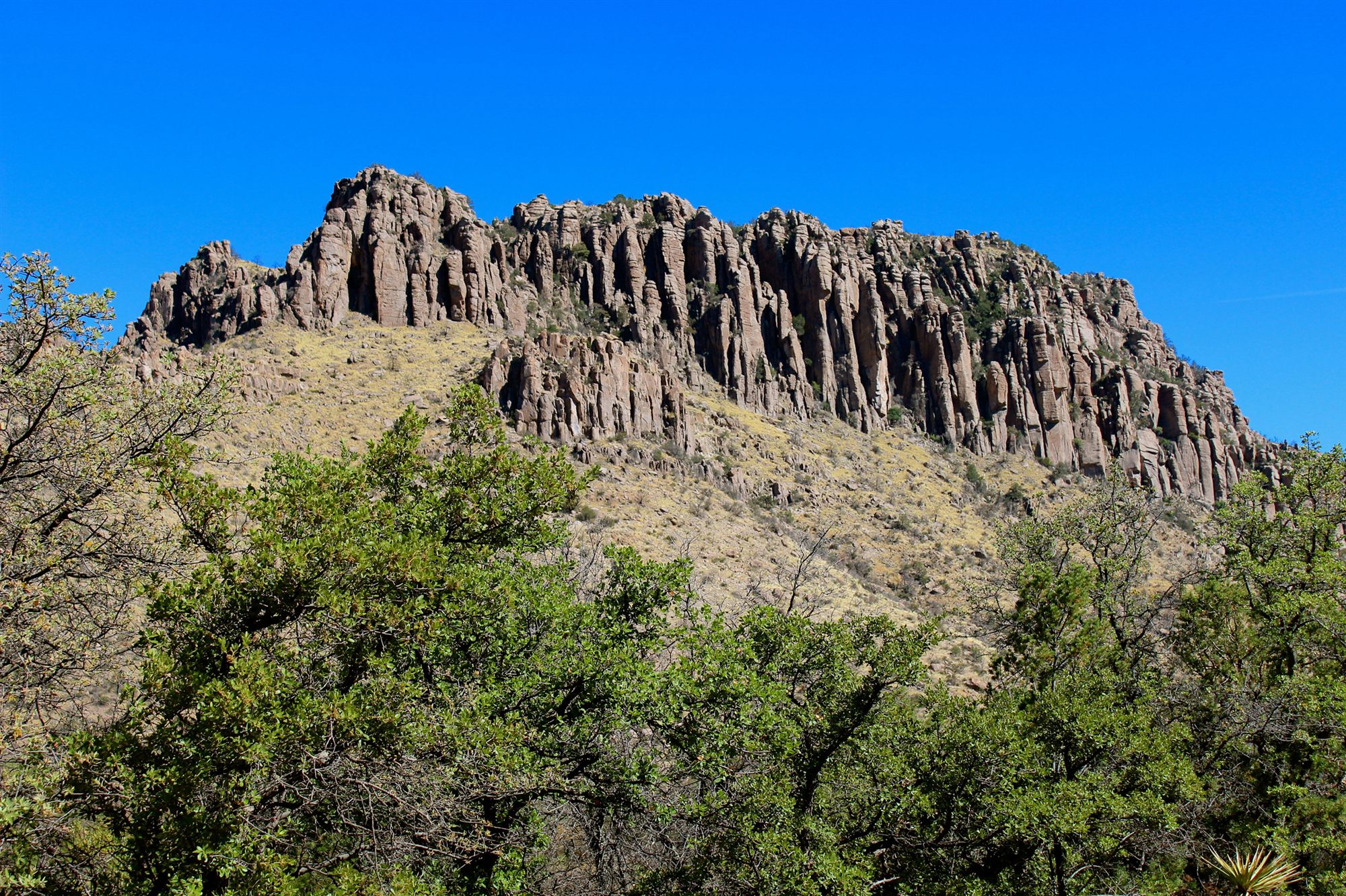
Chiricahua National Monument at a Glance
Tucked into a remote corner of southeastern Arizona, thousands of rock spires rise from a forested mountain range like a stone forest of their own — a landscape so unusual that early visitors nicknamed it the "Wonderland of Rocks." Far from Arizona's more famous attractions, this monument rewards travelers willing to make the drive with a landscape unlike anywhere else in the state. Before exploring how it formed, here's the monument at a glance:
Located in Southeastern Arizona
The Chiricahua Mountains
Protected National Monument
Managed by the National Park Service
"Wonderland of Rocks"
The monument's enduring nickname
More Than 12,000 Acres
Of volcanic rock and forested mountains
Volcanic Origin
Formed by a massive eruption 27 million years ago
Sky Island Ecosystem
A forested mountain rising from the desert
National Park Service Site
Preserved for research and visitation
Why Visit Chiricahua National Monument?
This is one of Arizona's quietest, strangest, and most rewarding landscapes, tucked far enough off the beaten path that many longtime Arizona residents have never made the trip. Here's what makes it worth the journey:
Incredible Rock Formations
Thousands of stone spires, pinnacles, and balanced boulders found nowhere else in the state.
Volcanic Geology
A landscape shaped by one of the largest volcanic eruptions in the region's history.
Mountain Scenery
A forested Sky Island rising dramatically above the surrounding desert.
Wildlife
A rare overlap of desert, mountain, and tropical species in one place.
Photography
Dramatic stone towers and balanced rocks framed by oak and pine forest.
Hiking
Trails winding directly through the heart of the rock formations.
Birdwatching
One of the premier birdwatching destinations in the United States.
Dark Skies
Remote, uncrowded skies far from city light pollution.
Peaceful Atmosphere
A quiet alternative to Arizona's busier, more famous landscapes.
The Wonderland of Rocks
What Makes the Rock Formations Unique?
Nowhere else in Arizona do you find quite this density and variety of standing stone. Early visitors reportedly struggled to describe what they were seeing, and the name "Wonderland of Rocks" stuck precisely because no single, ordinary description felt adequate. The monument's rock formations take several distinct forms, each shaped by the same volcanic origin but sculpted differently by time.
Balanced Rocks: Large boulders perched precariously atop narrower stone columns, appearing to defy gravity, formed as softer surrounding rock eroded away faster than the harder cap stone above it. Some of these balanced formations have remained in what looks like an impossibly precarious position for centuries, protected by the very erosion patterns that created them.
Rock Pinnacles: Tall, narrow spires rising directly from the mountainside, created where vertical cracks in the volcanic rock guided erosion into columns rather than smooth slopes. Many stand in dense clusters, forming what looks from a distance like a stone forest rather than individual formations.
Hoodoos: Irregular, top-heavy stone towers with narrow bases and bulkier upper sections, among the most photographed formations in the monument. Their asymmetric, almost sculptural shapes result from uneven erosion rates within the same rock layer.
Natural Towers: Entire clusters of rock rising together like a stone skyline, some reaching hundreds of feet above the surrounding slopes, visible for miles from certain vantage points within the monument.
All of these formations share the same origin story: millions of years of volcanic activity followed by patient, relentless erosion, sculpting a single type of rock into an extraordinary range of shapes. Trails winding directly through Echo Canyon and the Heart of Rocks area let visitors walk among these formations at close range, rather than simply viewing them from a distance. Names given to individual formations over the years — Duck on a Rock, Big Balanced Rock, Punch and Judy — reflect just how much these shapes have captured the imagination of visitors for generations.
A Landscape Born from Volcanoes
Massive Volcanic Eruptions
Around 27 million years ago, a colossal volcanic eruption from a nearby caldera released an enormous volume of ash and volcanic material across the region — among the largest eruptions in the geologic history of the American Southwest, dwarfing anything the region has experienced in recorded human history.
Ash Deposits
That eruption blanketed the landscape in volcanic ash and pumice, in places accumulating in layers well over a thousand feet thick, burying the older terrain beneath a deep, hot mass of volcanic debris. The sheer volume of material involved is difficult to overstate — entire pre-existing valleys and hills were buried completely beneath the new volcanic deposit.
Cooling and Solidifying
As the ash cooled, it welded and compacted into a hard volcanic rock called rhyolitic tuff — strong enough to stand as towering cliffs, but laced with vertical fractures that would later determine exactly how it eroded. The specific mineral composition and cooling conditions of this particular tuff are part of why it eroded into such distinctive columns rather than the smoother slopes seen in many other volcanic landscapes.
Millions of Years of Erosion
Over the millions of years since, wind, rain, and repeated freeze-thaw cycles worked along those natural fracture lines, slowly carving the once-solid rock mass into the towers, spires, and balanced boulders visible today. Water seeping into cracks and freezing repeatedly acted almost like a slow-motion chisel, widening fractures year after year until individual columns separated fully from the surrounding rock.
Today's Landscape
The result is one of the finest examples of volcanic erosion anywhere in the world — a landscape that looks almost sculpted by hand, but is entirely the product of natural forces working patiently across geologic time. Erosion here hasn't stopped either; the same slow processes that created these formations continue to reshape them today, meaning the Wonderland of Rocks is still, quietly, a work in progress. For a deeper look at the broader forces that shaped Arizona's rock layers, see our full Arizona Geology → guide.
How the Wonderland of Rocks Was Created
Seeing the whole process laid out in sequence makes the scale of it easier to grasp:
| Stage | What Happened |
|---|
| Massive volcanic eruption | Thick layers of volcanic ash covered the landscape. |
| Compaction | The ash hardened into volcanic rock called rhyolitic tuff. |
| Uplift | The land slowly rose over time. |
| Erosion | Wind, rain, and freezing temperatures sculpted the rock into towers, pinnacles, and balanced formations. |
| Today | Visitors explore one of the world's finest examples of volcanic erosion. |
The Sky Islands
Few travel guides explain this concept, and almost no visitors arrive in Arizona already knowing about it — which makes it one of the most quietly fascinating things about this monument.
A "Sky Island" is an isolated mountain range that rises abruptly out of a surrounding sea of desert and grassland, creating conditions closer to a much wetter, cooler climate at its summit than at its base, just a short distance away. The Chiricahua Mountains are one of the best examples of this phenomenon anywhere in the country, part of a broader network of similar ranges scattered across southeastern Arizona, southwestern New Mexico, and northern Mexico, collectively known as the Madrean Sky Islands.
What makes Chiricahua biologically unique is where it sits on the map: close enough to the Rocky Mountains to share species with the north, close enough to Mexico's Sierra Madre to share species with the south, and surrounded by both Sonoran and Chihuahuan desert influences. Species from all of these regions overlap here, in a way that happens in very few other places on the continent. Biologists sometimes describe this convergence zone as one of the richest overlap points for biodiversity anywhere in North America, precisely because so many distinct biological regions brush up against one another in such a small area.
That overlap is driven directly by elevation. Desert grassland at the base gives way to oak woodland partway up the mountain, which in turn gives way to pine and fir forest near the highest elevations — entirely different ecosystems separated by only a few thousand feet of elevation change and a short drive or hike. Each elevation band supports its own distinct community of plants and animals, layered on top of one another like a stack of separate, smaller ecosystems compressed into a single mountain range. A single day's hike here can move you through vegetation zones that, in flatter terrain, might otherwise be separated by hundreds of miles of latitude.
The result is extraordinary biodiversity packed into a relatively small area: species you'd expect to find only in Mexico, the Rocky Mountains, or the Sonoran Desert can all turn up within a few miles of each other here, which is exactly why Chiricahua draws birdwatchers, biologists, and naturalists from around the world. For many serious birders in particular, a single trip to these canyons can add species to a life list that would otherwise require travel to entirely different countries.
Arizona's Sky Islands
Laid out side by side, the contrast between the desert floor and the Sky Island summit above it becomes easy to see:
| Desert Floor | Sky Island Mountains |
|---|
| Hotter temperatures | Cooler climate |
| Cactus and desert shrubs | Pine, oak, and juniper forests |
| Desert wildlife | Mountain wildlife |
| Lower rainfall | Higher rainfall |
| Open landscapes | Forested mountain slopes |
Plants and Wildlife
The overlapping ecosystems of this Sky Island support a genuinely unusual mix of wildlife, much of it found in few other places in the country. Because elevation here shifts so quickly across a relatively short distance, wildlife more typical of Mexico's mountains and wildlife more typical of the American Southwest's deserts frequently turn up within the same small area, sometimes even the same short hike.
- Black Bear — found throughout the mountain's forested elevations, taking advantage of the range's relative seclusion.
- Coatimundi — a long-tailed relative of the raccoon, more commonly associated with Mexico and Central America, found here near the northern edge of its range.
- Javelina — social, pig-like mammals often seen at lower, drier elevations near the monument's edges.
- Mexican Jay — a bold, social bird common in the oak woodlands partway up the mountain.
- Elegant Trogon — a strikingly colorful, tropical bird that draws birdwatchers from around the country, found in the U.S. almost exclusively in a handful of these southeastern Arizona Sky Island canyons.
- White-tailed Deer — including the smaller Coues subspecies, well adapted to the mountain's oak and pine woodlands.
- Mountain Lions — elusive top predators that move through the range's more remote, forested terrain.
Vegetation shifts just as dramatically with elevation, from desert wildflowers and juniper at lower elevations to dense oak woodlands and, eventually, pine forest near the highest points of the range. Alligator juniper, with its distinctive thick, plated bark, and Apache pine, found in the United States almost exclusively in these southeastern Arizona Sky Islands, are among the more unusual species that make the higher elevations here feel more like the mountains of Mexico than the Arizona most visitors expect.
For a closer look at the animals found throughout the wider region, see our full Arizona Wildlife → guide.
Indigenous History
The Chiricahua Mountains are the traditional homeland of the Chiricahua Apache, the band of Apache people who take their name directly from this very mountain range. For generations, the Chiricahua Apache developed deep, practical knowledge of this rugged terrain — its hidden water sources, defensible high ground, and safe travel routes through country that looks impenetrable to outsiders. That knowledge was built over centuries of living within these mountains, not simply passing through them, and it shaped a deep, practical relationship with a landscape that demanded both respect and skill to navigate safely.
This land holds deep cultural and historical significance that extends well beyond scenery. The Chiricahua Apache maintain living cultural connections to this landscape today, and their history here is part of a continuing heritage, not a closed chapter of the past. Descendant communities continue to hold this mountain range as a place of deep ancestral importance, and that connection continues to shape how the National Park Service approaches the monument's interpretation and stewardship today. Visiting this monument respectfully means recognizing it as a homeland with a long, continuing human story, not simply a striking rock formation to photograph.
Cochise and the Chiricahua Mountains
Few names are as closely tied to this landscape as Cochise, the influential Chiricahua Apache leader who knew these mountains intimately during a turbulent period of conflict in the mid-to-late 1800s. The rugged, maze-like terrain of the Chiricahua Mountains — steep canyons, hidden water sources, and countless natural hiding places among the rock formations — made this range a natural stronghold, extraordinarily difficult for outside forces to navigate or control. A visible rock formation within the wider range, resembling a face in profile, is popularly known today as Cochise Head, a lasting reminder of how closely his name remains tied to this country.
Cochise's deep knowledge of this country, and his people's long history within it, allowed the Chiricahua Apache to hold this territory for years against considerable pressure, from both Mexican and American forces operating in the region. That history is a central part of what makes this landscape significant well beyond its geology: the same natural features that draw hikers and photographers today — the rock towers, the hidden canyons, the difficult terrain — were once matters of genuine strategic and survival importance to the people who called these mountains home. Eventually, after years of conflict, Cochise negotiated peace terms that allowed his people to remain in a reservation encompassing part of their traditional homeland, a rare outcome for the era.
This history deserves to be told with care and historical grounding, not romanticized or reduced to a simple frontier story. It's a chapter of sustained resistance and deep, intimate knowledge of place, carried out by people defending a homeland they had known for generations, and it remains a meaningful part of Chiricahua Apache history and identity today.
Chiricahua Through the Seasons
Spring
Wildflowers bloom across the lower elevations and hiking weather is close to ideal, making spring one of the most rewarding times to explore the rock formations on foot before summer heat and monsoon activity set in.
Summer
Monsoon clouds build dramatically over the peaks each afternoon, and the mountain's higher elevations stay noticeably cooler than the desert floor far below, offering welcome relief during Arizona's hottest months.
Fall
Oak woodlands turn shades of gold and bronze, paired with excellent visibility and some of the most comfortable hiking conditions of the year, making it a favorite season among frequent visitors.
Winter
Snow occasionally dusts the rock formations, creating a rare, quiet contrast between white snow and dark volcanic stone, with noticeably thinner crowds than any other season and some of the clearest, calmest air all year.
Interesting Facts About Chiricahua
A handful of details tend to surprise first-time visitors most:
- Nicknamed the "Wonderland of Rocks" for its extraordinary density of stone spires and balanced formations.
- Some rock towers rise hundreds of feet above the surrounding landscape.
- The monument protects a remarkable Sky Island ecosystem, layering desert, woodland, and forest habitats within a single mountain range.
- Home to more bird species than many national parks, thanks to its unique overlap of desert, mountain, and tropical species.
- Volcanic eruptions roughly 27 million years ago created the raw material for today's spectacular rock formations.
- The monument was established in 1924, protecting the Wonderland of Rocks decades before many of Arizona's other well-known parks and monuments.
- A scenic drive climbs from the monument's lower elevations up to Massai Point, gaining substantial elevation in just a few miles and passing through several distinct vegetation zones along the way.
Why Chiricahua Is One of Arizona's Hidden Gems
Compared to Arizona's most famous landmarks, Chiricahua sees a fraction of the visitors — and that's precisely part of its appeal. Trails here rarely feel crowded, viewpoints often belong to just a handful of visitors at a time, and the pace of a visit tends to feel unhurried in a way that's increasingly rare at Arizona's better-known destinations. Even during the state's busiest travel seasons, it's entirely possible to spend an afternoon here without encountering more than a few other hikers.
It's also simply unlike anywhere else in the state. Where the Grand Canyon overwhelms with sheer scale, Chiricahua rewards close, careful looking — the detail in a single balanced rock, the sudden appearance of a tropical bird species far from where you'd expect it, the quiet of a forest trail winding between stone towers. It's a different kind of extraordinary: quieter, more intimate, and, for many visitors who make the trip, every bit as unforgettable as Arizona's more famous landscapes. For travelers willing to go a little further off the well-worn path, it's one of the most rewarding detours in the entire state.
Arizona's Landscapes Through Time
Chiricahua is a fitting place to end this journey through Arizona's National Parks and Monuments, because it draws together nearly everything this series has explored: volcanic history, deep geologic time, rare ecosystems, Indigenous history, and landscapes unlike anywhere else on Earth. No single monument in this series could tell that whole story alone — it took nine very different landscapes, each shaped by a different force, to cover the full arc. Read in sequence, these places trace Arizona's story across hundreds of millions of years:
Petrified ForestAncient tropical forests
↓
Grand CanyonMillions of years of erosion
↓
Sunset CraterVolcanic fire
↓
WupatkiHuman adaptation
↓
Walnut CanyonLife among the cliffs
↓
Montezuma CastleIngenious engineering
↓
TuzigootTrade and thriving communities
↓
Organ Pipe CactusThe Sonoran Desert ecosystem
↓
ChiricahuaThe Wonderland of Rocks
By the time you've explored all nine of these places, one thing becomes clear: Arizona isn't defined by a single iconic landscape. It's a state of astonishing diversity — deserts and canyons, ancient forests and volcanoes, cliff dwellings and thriving trade centers, and mountain Sky Islands rising unexpectedly out of the desert floor. That range is exactly what makes exploring Arizona, chapter by chapter, so rewarding.
Each of these nine places also tells its story through a genuinely different natural process — fossilization, erosion, volcanic eruption, human adaptation, cliff architecture, engineering, trade, desert ecology, and, finally, the layered biodiversity of a Sky Island. Few states pack this much geological and ecological variety into a single, connected travel itinerary, and fewer still tell that story as one continuous narrative rather than a list of separate stops.
Frequently Asked Questions
What is Chiricahua famous for?
Chiricahua is best known for its extraordinary concentration of volcanic rock spires, balanced boulders, and hoodoos, earning it the nickname "Wonderland of Rocks," along with its unusual Sky Island ecosystem and rich birdwatching opportunities.
Why is it called the Wonderland of Rocks?
The name reflects the sheer density and variety of unusual rock formations packed into a relatively small area, unlike anything else in Arizona, from balanced boulders to towering stone pinnacles.
How were the rock formations created?
A massive volcanic eruption roughly 27 million years ago deposited thick layers of ash, which compacted into rhyolitic tuff; millions of years of subsequent erosion carved that rock into today's towers, pinnacles, and balanced formations, a process that continues gradually even today.
What is a Sky Island?
A Sky Island is an isolated mountain range surrounded by desert, where elevation change creates dramatically different, layered ecosystems within a short distance, from desert grassland to pine forest, packed into a single mountain range.
What animals live here?
Black bear, coatimundi, javelina, Mexican jay, elegant trogon, white-tailed deer, and mountain lions are among the wide range of species supported by the monument's overlapping ecosystems, alongside hundreds of recorded bird species.
Who was Cochise?
Cochise was an influential Chiricahua Apache leader whose deep knowledge of the Chiricahua Mountains' rugged terrain made the range a natural stronghold during a turbulent period of conflict in the 1800s, eventually negotiating a peace that allowed his people to remain on part of their traditional homeland.
Why is Chiricahua protected?
The monument preserves a rare volcanic landscape, a biologically significant Sky Island ecosystem, and a homeland of deep, continuing importance to the Chiricahua Apache.
What makes it different from other Arizona parks?
Its combination of dense volcanic rock formations, layered Sky Island ecosystems, and relative solitude sets it apart from Arizona's larger, more heavily visited parks and monuments, offering a quieter, more intimate kind of extraordinary.
Continue Exploring Arizona
Chiricahua closes out this journey through Arizona's National Parks and Monuments. Here's where to revisit the rest of the story:
Petrified Forest National Park
Ancient forests turned to stone across 225 million years.
READ GUIDE →Organ Pipe Cactus National Monument
The remarkable biodiversity of the Sonoran Desert.
READ GUIDE →Arizona Geology
The volcanic and geological forces that shaped the state.
READ GUIDE →Arizona Wildlife
The animals that call these landscapes home.
READ GUIDE →Arizona Photography
Capturing Arizona's light, landscapes, and desert color.
READ GUIDE →
Experience Arizona's Hidden Wonders with Grand Canyon Journeys
Chiricahua National Monument reveals a side of Arizona that many travelers never experience. Towering volcanic rock formations, remarkable wildlife, and the rich history of the Chiricahua Mountains make this one of the state's most extraordinary landscapes. Together with Arizona's other iconic destinations, it showcases the incredible diversity that makes the state such a remarkable place to explore, from its deserts and canyons to its volcanic Sky Islands.