Lake Powell at a Glance
Straddling the Arizona-Utah border near Page, Arizona, Lake Powell is a vast reservoir created by Glen Canyon Dam on the Colorado River, its shoreline winding through dozens of flooded side canyons carved from sandstone. It sits within Glen Canyon National Recreation Area, closely connected to Antelope Canyon, Horseshoe Bend, and the wider Glen Canyon landscape that surrounds it.
Arizona-Utah Border
Near Page, Arizona
Created by Glen Canyon Dam
On the Colorado River
Glen Canyon National Recreation Area
Managed by the National Park Service
Sandstone Cliffs and Side Canyons
A sculpted desert landscape
Connected to Page and Antelope Canyon
And Horseshoe Bend nearby
Boating, Photography, and Geology
A landscape of striking desert scenery
What Is Lake Powell?
Lake Powell is a human-made reservoir, not a natural lake, formed when Glen Canyon Dam blocked the Colorado River and rising water gradually filled the canyon behind it. That distinction matters: rather than occupying a natural basin, Lake Powell fills a landscape that was, until the mid-20th century, a deep, winding river canyon system, and the reservoir's entire shape follows the contours of that flooded terrain rather than any natural lakebed.
The Colorado River and numerous tributary streams feed the reservoir, and Lake Powell's famously convoluted shoreline traces the paths of the river's former main channel along with dozens of narrow side canyons that once carried seasonal water into it. Because so much of the reservoir occupies these narrow, flooded side canyons rather than open water, Lake Powell's shoreline is dramatically longer, relative to its surface area, than a natural lake of comparable size would typically have.
Water levels here are not fixed. Lake Powell's surface elevation rises and falls considerably depending on snowpack, drought, water releases, and regional demand, continually altering how much shoreline is visible, which side canyons remain accessible by water, and how the reservoir's edges meet the surrounding sandstone. Understanding Lake Powell means understanding it as a genuinely dynamic, engineered landscape, not a fixed, unchanging body of water.
That engineered character also shapes how the reservoir behaves compared to a natural lake. Water managers control outflow through Glen Canyon Dam according to downstream needs, seasonal planning, and broader Colorado River system agreements, meaning the reservoir's level reflects deliberate management decisions as much as it reflects natural inflow. Visitors accustomed to natural lakes, where water levels change gradually and predictably with the seasons, often find Lake Powell's more variable, managed behavior genuinely distinctive once they understand the reservoir's true nature.
How Lake Powell Was Created
Glen Canyon Before the Reservoir
Before the dam, Glen Canyon was a deep, winding corridor carved by the Colorado River through Navajo and Wingate sandstone, its walls sculpted into narrow side canyons, natural alcoves, and dramatic rock formations over millions of years. The canyon held significant archaeological and cultural resources, including sites connected to Ancestral Puebloan and other Indigenous communities who had used this stretch of the river corridor for many centuries. Early river travelers, including John Wesley Powell's pioneering 1869 and 1871 expeditions down the Colorado River, documented Glen Canyon's remarkable scenery well before the idea of a dam here was ever seriously proposed.
Construction of Glen Canyon Dam
Glen Canyon Dam was built during the 1950s and 1960s as part of a broader mid-20th-century effort to manage the Colorado River's water for the benefit of the growing cities, farms, and states that depend on it. The dam serves several distinct purposes at once: storing water for use during dry years, generating hydroelectric power for the region, and giving water managers greater control over the timing and volume of Colorado River flows reaching downstream users.
Filling Lake Powell
Once the dam was completed, rising water gradually filled the main stem of Glen Canyon along with dozens of tributary side canyons, a process that took years to reach the reservoir's fuller operating levels. That flooding submerged considerable stretches of the canyon's original riverbed, including some archaeological and geological features, while also creating the reservoir's now-famous network of narrow, water-filled canyon fingers extending outward from the main body of the lake.
Lake Powell Today
Today, Lake Powell serves multiple overlapping roles: a major recreation destination for boating and camping, a significant regional water storage facility, a hydroelectric power source, an active site of ongoing scientific research into reservoir management and Colorado River hydrology, and a substantial contributor to tourism in the Page area and the wider region. Current water levels and operating conditions change over time with drought, snowpack, and water management decisions, so visitors and researchers alike should consult official National Park Service and Bureau of Reclamation sources for up-to-date figures rather than relying on any fixed number.
The Geology of Lake Powell
Navajo Sandstone
Much of the pale, sweeping rock visible around Lake Powell is Navajo Sandstone, formed from vast fields of windblown sand dunes roughly 190 million years ago and later cemented into stone. The same cross-bedded, diagonal layering visible at Antelope Canyon appears throughout the cliffs surrounding the reservoir, a fossilized record of ancient dune slopes preserved in rock.
Wingate Sandstone
Beneath the Navajo Sandstone, the older, harder Wingate Sandstone forms many of the tall, sheer, vertical cliffs found throughout Glen Canyon, its resistance to erosion producing dramatic, sharply defined canyon walls distinct from the more rounded, sweeping forms typical of Navajo Sandstone above it.
The Colorado Plateau
Both of these formations were later lifted, along with the surrounding region, during the broad uplift of the Colorado Plateau, a process that steepened the gradient of the Colorado River and its tributaries and gave them the erosive energy needed to cut deeply into the rising rock rather than simply spreading out across it. That same uplift is responsible for the Grand Canyon farther downstream, part of a single, connected geological story spanning much of the Southwest.
Water and Sandstone
Flowing water, wind-carried sediment, and seasonal weathering have worked together over millions of years to sculpt the alcoves, narrow passages, sheer cliffs, and winding side canyons that define the Glen Canyon landscape today. This is the same fundamental process responsible for Antelope Canyon → and Horseshoe Bend → nearby, each shaped by a different expression of water working on the same sandstone. For the fuller regional and geological picture, see our Arizona Geology → and Grand Canyon Geology → guides.
Why Lake Powell Looks So Dramatic
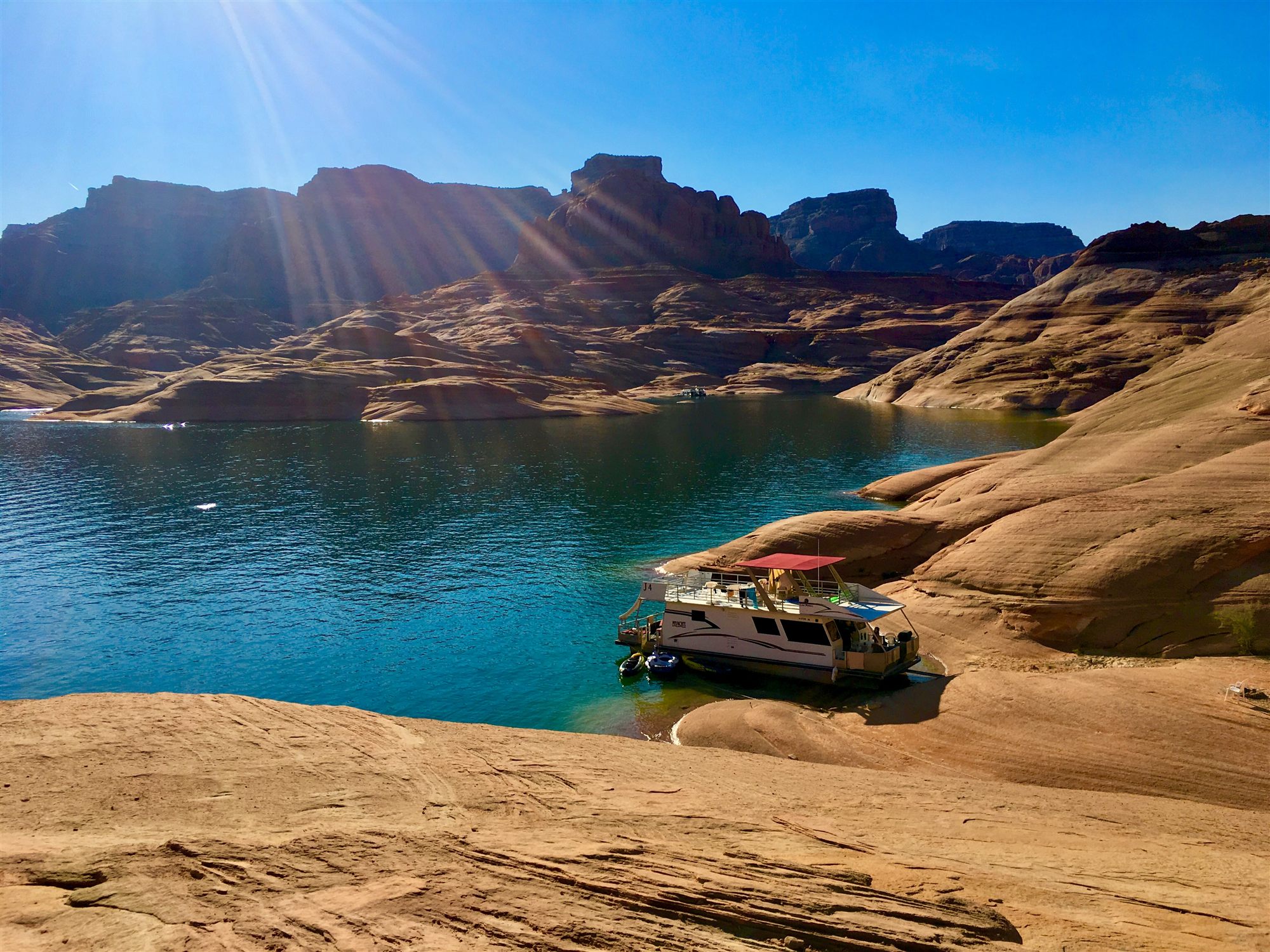
Part of what makes Lake Powell so visually striking is contrast, layered again and again throughout the landscape. Deep blue and green water sits against pale and red sandstone, open desert gives way abruptly to narrow, shaded canyon walls, and the sheer scale of the surrounding cliffs makes even a large boat on the water look small by comparison.
Light plays a constant role in that drama. Shadows shift considerably across the day as the sun moves, deepening the contrast between sunlit rock and shaded canyon interior, while the water itself reflects the surrounding sandstone in ways that can make it difficult to tell where stone ends and reflection begins. Changing water levels add yet another visual layer, exposing bands of lighter, water-stained rock, sediment, and rock shelves that mark where the reservoir's surface has stood at different points over time.
None of this is a fixed, unchanging scene. Lake Powell looks different by the hour, by the season, and by the year, a landscape defined as much by ongoing change as by any single, static view.
Glen Canyon National Recreation Area
Lake Powell is only one part of a much larger protected landscape: Glen Canyon National Recreation Area, managed by the National Park Service and encompassing desert ecosystems, river corridors, cultural resources, and geological features extending well beyond the reservoir's shoreline itself. The recreation area includes stretches of the Colorado River both above and below the reservoir, along with surrounding desert terrain that supports its own distinct plant and animal communities.
Cultural resources within the recreation area, including archaeological sites tied to Indigenous communities who used this landscape for many centuries before the dam existed, receive protection alongside the area's geological and natural features. Recreation, from boating to hiking to photography, is balanced against genuine conservation responsibilities, an ongoing management challenge given the area's popularity and the sensitivity of much of what it protects.
Access rules, permits, seasonal closures, and current conditions across Glen Canyon National Recreation Area can change, sometimes with little notice. Visitors should consult official National Park Service guidance directly for current information before planning any visit, rather than relying on any single source, including this guide, for up-to-date access details.
Lake Powell and the Colorado River
The River That Feeds the Reservoir
The Colorado River, along with tributaries including the San Juan River, Escalante River, and numerous smaller side streams, supplies essentially all of Lake Powell's water, gathered from a watershed stretching back into the mountains of Colorado, Wyoming, and Utah, far upstream from the reservoir itself.
Water in the Desert Southwest
In a region where reliable water is scarce and demand from cities, agriculture, and industry is considerable, stored water carries outsized importance. Lake Powell functions as a major storage buffer for the Colorado River system, helping smooth out the difference between wetter and drier years for the millions of people and vast agricultural regions that depend on the river across multiple states.
A Changing Reservoir
Lake Powell's surface area and shoreline can change considerably over time, driven by snowpack in the river's headwaters, sustained drought, scheduled water releases, and regional water demand. These changes are a normal, expected part of how the reservoir functions as a water management tool, though the scale of recent change has drawn considerable public attention in recent years.
The Larger Colorado River System
Lake Powell does not exist in isolation. Water released from Glen Canyon Dam flows downstream through the Grand Canyon before eventually reaching Lake Mead, held back by Hoover Dam farther downstream, part of a single interconnected system of reservoirs and dams that together manage water for the entire Colorado River basin. Decisions made at Lake Powell directly affect conditions throughout this wider system, and vice versa, making it impossible to fully understand the reservoir without understanding its place in this much larger network.
The Cultural History of the Lake Powell Region
It's essential to understand that this landscape's history did not begin with Glen Canyon Dam. Indigenous peoples have maintained deep, sustained connections to the Colorado Plateau, including the Glen Canyon region, for many thousands of years, long before the reservoir existed and long before the canyon was known by its current English name.
The surrounding region includes significant Navajo Nation lands, and the wider area holds deep significance to the Navajo people alongside other tribal nations with historical and continuing ties to this landscape. Ancestral Puebloan communities also lived throughout Glen Canyon and the broader region for many centuries, leaving behind dwellings, rock art, and other archaeological resources, some of which now lie beneath the reservoir's waters while others remain preserved in areas surrounding it.
These archaeological and cultural resources deserve serious respect. Many sites throughout the region are protected, culturally sensitive, or both, and visitors should never disturb, remove, or damage any archaeological material encountered while exploring this landscape. Respectful engagement with this region's cultural history means recognizing it as a living, continuing story, not simply a backdrop to the reservoir's more recent history. For more on the Indigenous nations connected to this region, see our Navajo Nation →, Hopi Tribe →, and Arizona Native American Arts & Culture → guides, along with our Wupatki National Monument → guide for more on the region's Ancestral Puebloan history.
Wildlife and Plant Life Around Lake Powell
Desert Bighorn Sheep
Desert bighorn sheep navigate the steep sandstone terrain surrounding the reservoir with practiced ease, occasionally visible along canyon walls and rocky slopes near the water.
Coyotes and Small Mammals
Coyotes range across the surrounding desert, alongside a range of smaller mammals adapted to the area's arid conditions and limited water sources away from the reservoir itself.
Ravens and Raptors
Ravens are a near-constant presence throughout the region, while raptors including red-tailed hawks and peregrine falcons make use of the area's cliffs and open sky, with peregrines in particular favoring the tall sandstone walls found throughout Glen Canyon for nesting.
Reptiles
Numerous lizard species inhabit the sun-exposed sandstone surrounding the lake, well adapted to the intense heat and limited shade typical of this landscape.
Native Fish and Aquatic Life
Lake Powell's own fishery is dominated by introduced sport fish, including striped bass, smallmouth bass, and walleye, stocked over the decades since the reservoir's creation rather than naturally occurring here. Native Colorado River fish, including species such as the humpback chub, are a considerably greater concern downstream in the Colorado River corridor and Grand Canyon, where dam operations have significantly altered the water temperature, flow, and sediment conditions these native species evolved to depend on.
Desert Plants
Juniper, sagebrush, rabbitbrush, and various cactus species cover much of the surrounding desert terrain, adapted to minimal rainfall and extreme temperature swings. Along parts of the shoreline and river corridor, tamarisk, also known as salt cedar, has become a widespread and ecologically disruptive invasive species, outcompeting native riparian vegetation such as cottonwood and willow in many areas; land managers continue active efforts to control tamarisk and support native riparian plant recovery throughout the wider Colorado River system. For a closer look at the animals found throughout the wider region, see our full Arizona Wildlife → guide.
Lake Powell Through the Seasons
Spring
Spring generally brings mild conditions alongside considerable wind, with water temperatures still cool from winter and, in favorable years, desert wildflower blooms across the surrounding terrain.
Summer
Summer brings intense heat and strong sun exposure across the open water and exposed sandstone, along with monsoon season's potential for sudden, fast-moving storms. Conditions can change rapidly during this season, making hydration and general weather awareness a serious, ongoing consideration rather than an afterthought.
Fall
Fall typically offers cooler days, softer light, and generally clearer conditions than the more volatile summer monsoon season, making it a favored season among many longtime visitors.
Winter
Winter brings cold mornings, a noticeably quieter landscape with fewer visitors, and occasional snow dusting the sandstone cliffs surrounding the lake. Some services and access points may operate on reduced schedules during the winter months, and conditions can vary considerably from year to year, so specific guarantees about winter access or services should not be assumed without checking current official information.
Photography at Lake Powell
Lake Powell rewards photographers with an unusual combination of elements rarely found together: still water reflections, richly textured sandstone, dramatic scale, and constantly shifting waterlines that reveal different bands of color and texture depending on current conditions. Morning and evening light generally produce the richest color and most dramatic shadow across the surrounding cliffs, while midday light tends to flatten contrast considerably.
Clouds and storm systems, particularly during monsoon season, can produce genuinely dramatic skies worth watching for, though they also demand caution given how quickly conditions can change over open water. Telephoto lenses excel at isolating distant canyon details and compressing the scale of the surrounding cliffs, while wide-angle lenses better capture the sweeping, open scale of the main reservoir and its dramatic shoreline.
Drone photography is subject to specific rules within Glen Canyon National Recreation Area and can change over time; visitors interested in drone use should check current National Park Service regulations directly before flying, rather than assuming any particular set of rules remains in effect. For more on capturing this region's scenery, see our Arizona Photography → guide, along with our Antelope Canyon → and Horseshoe Bend → guides.
How Lake Powell Connects Northern Arizona's Landscapes
Lake Powell sits at the center of a genuinely interconnected regional landscape, linked directly to several of Northern Arizona's most significant destinations.
| Landscape | Connection to Lake Powell |
|---|
| Colorado River | Supplies most of the reservoir's water. |
| Glen Canyon | The flooded canyon system beneath and around the reservoir. |
| Antelope Canyon | Formed in nearby Navajo Sandstone by flowing water. |
| Horseshoe Bend | A dramatic Colorado River meander downstream from Glen Canyon Dam. |
| Navajo Nation | Surrounds much of the broader Page and Lake Powell region. |
| Grand Canyon | Receives Colorado River water released below Glen Canyon Dam. |
| Vermilion Cliffs | Part of the wider Colorado Plateau landscape. |
A Landscape That Changes with the Water
Perhaps more than any other major landscape in Arizona, Lake Powell resists being described as a single, fixed scene. As water elevation rises and falls, the reservoir continually reveals or covers beaches, rock shelves, canyon walls, side passages, former shorelines, layers of sediment, and entire vegetation zones that shift depending on how high or low the water currently sits.
A cove that holds deep water in one season may expose a wide sandstone shelf or sandy beach the next, while side canyons that once allowed boat access may become impassable, and previously submerged rock features may reappear after years underwater. Vegetation along the shoreline shifts in response to these same changes, with plants establishing themselves on newly exposed ground only to be submerged again when water levels rise.
This gives Lake Powell a genuinely distinctive character among Arizona's landscapes: it is not one fixed place, but a continually changing meeting point between river, reservoir, desert, and stone, different in real, physical ways from one year to the next.
Lake Powell and Nearby Natural Wonders
Lake Powell sits within a remarkable concentration of Northern Arizona's most celebrated landscapes, each worth understanding in its own right.
Antelope Canyon
A world-famous slot canyon carved from Navajo sandstone nearby.
READ GUIDE →Horseshoe Bend
A dramatic Colorado River meander just downstream.
READ GUIDE →Glen Canyon
The sculpted canyon system surrounding the reservoir.
READ GUIDE →Vermilion Cliffs
Towering, colorful sandstone escarpments nearby.
READ GUIDE →Grand Staircase-Escalante
A vast, layered landscape of cliffs and canyons to the north.
READ GUIDE →Grand Canyon National Park
The centerpiece of Arizona's geological story downstream.
READ GUIDE →Navajo Nation
The largest Native American reservation, surrounding much of the region.
READ GUIDE →Page, Arizona
The gateway town at the heart of the Lake Powell region.
READ GUIDE →
Environmental Questions Surrounding Lake Powell
Lake Powell is not simply a scenic destination — it is also a genuinely debated landscape, at the center of ongoing conversations about Colorado River management that extend well beyond Arizona. It's worth understanding this dimension of the reservoir honestly, alongside its recreational and scenic value.
Sustained drought across the Colorado River basin in recent decades has placed real strain on the entire reservoir system, raising difficult questions about how water storage, hydroelectric power generation, and downstream water delivery can all be balanced as available water becomes less predictable. Evaporation from the reservoir's large surface area, along with water lost to sediment accumulation over time, represent ongoing considerations in how efficiently the reservoir stores water relative to alternatives.
Ecological effects of the dam and reservoir remain a significant, active area of concern, particularly regarding native fish species and natural sediment flow through the Grand Canyon downstream, both substantially altered by decades of dam operation. Some conservation advocates, most notably the Glen Canyon Institute, have proposed draining Lake Powell entirely and restoring Glen Canyon to something closer to its pre-dam state, arguing that the reservoir's ecological costs and water losses to evaporation and seepage outweigh its benefits. Others, including water managers and many regional stakeholders, emphasize the reservoir's essential role in water storage and drought resilience for the millions of people and vast agricultural areas that depend on the Colorado River system, arguing that removing this storage capacity would create serious water security risks.
These are genuinely contested questions, weighed differently by different stakeholders across the Colorado River basin, and this guide does not take a position on how they should ultimately be resolved. Understanding Lake Powell honestly means understanding it as both a remarkable landscape and a real, ongoing policy debate, not simply one or the other.
Visitors interested in these issues can find detailed, current information through official sources including the Bureau of Reclamation, the National Park Service, and the various river-basin states and tribal nations that participate in Colorado River management, all of which publish regular updates on reservoir conditions, water allocation, and planning discussions as they continue to evolve.
Interesting Facts About Lake Powell
- Lake Powell extends across both Arizona and Utah.
- It was created by the construction of Glen Canyon Dam on the Colorado River.
- Its shoreline length changes considerably as water elevation rises and falls.
- The reservoir contains numerous narrow, flooded side canyons.
- It is part of Glen Canyon National Recreation Area, managed by the National Park Service.
- Its surrounding cliffs expose layers of Navajo and Wingate sandstone from the Colorado Plateau.
- The reservoir is named after John Wesley Powell, the explorer who led early expeditions down the Colorado River.
Frequently Asked Questions About Lake Powell
Is Lake Powell a natural lake?
No. Lake Powell is a human-made reservoir, created when Glen Canyon Dam blocked the Colorado River and rising water filled the canyon behind it.
Where is Lake Powell located?
Lake Powell straddles the Arizona-Utah border near Page, Arizona, within Glen Canyon National Recreation Area.
Why was Lake Powell created?
It was created to store Colorado River water, generate hydroelectric power, and give water managers greater control over river flows for the benefit of downstream users across the region.
What river feeds Lake Powell?
The Colorado River is the primary source, joined by tributaries including the San Juan and Escalante rivers.
Is Lake Powell part of a national park?
It's part of Glen Canyon National Recreation Area, a unit of the National Park System distinct from a national park, though managed by the same agency.
Why do Lake Powell's water levels change?
Water levels shift with snowpack in the river's headwaters, ongoing drought conditions, scheduled water releases, and regional water demand across the Colorado River system.
What type of rock surrounds Lake Powell?
Primarily Navajo Sandstone and Wingate Sandstone, both formed many millions of years ago and later exposed by the uplift and erosion of the Colorado Plateau.
How is Lake Powell connected to the Grand Canyon?
Water released from Glen Canyon Dam flows downstream through the Grand Canyon before eventually reaching Lake Mead, making Lake Powell and the Grand Canyon part of the same connected river system.
What Indigenous nations are connected to the region?
The Navajo Nation surrounds much of the region, and the area holds historical significance for the Hopi Tribe and other Indigenous communities with ties to the Colorado Plateau, alongside a long Ancestral Puebloan history predating the reservoir by many centuries.
What makes Lake Powell visually unique?
The combination of deep blue-green water, dramatic sandstone cliffs, narrow side canyons, and constantly shifting waterlines creates a visual contrast and scale found in few other places.
Can changing weather affect conditions quickly?
Yes — particularly during monsoon season, when storms can develop rapidly over open water, making weather awareness an important, ongoing consideration for anyone visiting.
Where should visitors check current access information?
Always consult the official National Park Service Glen Canyon National Recreation Area website and local management sources directly for current access rules, permits, closures, and water conditions before planning a visit.
Continue Exploring Northern Arizona
Lake Powell connects to a wider network of extraordinary landscapes across Northern Arizona and the Colorado Plateau. Here's where to go next:
Antelope Canyon
A world-famous slot canyon nearby.
READ GUIDE →Horseshoe Bend
A dramatic Colorado River meander downstream.
READ GUIDE →Navajo Nation
The largest Native American reservation in the United States.
READ GUIDE →Vermilion Cliffs
Towering, colorful sandstone escarpments nearby.
READ GUIDE →Grand Canyon National Park
The centerpiece of Arizona's geological story.
READ GUIDE →Arizona Geology
The deeper rock record behind the state's scenery.
READ GUIDE →Arizona Wildlife
The animals that call Arizona's varied landscapes home.
READ GUIDE →Page, Arizona
The gateway town at the heart of the Lake Powell region.
READ GUIDE →
Discover the Landscapes of Northern Arizona with Grand Canyon Journeys
Lake Powell reveals another extraordinary side of Northern Arizona, where water, sandstone, desert light, and the geology of the Colorado Plateau combine to create a landscape unlike anywhere else in the region. Understanding how Lake Powell connects with Antelope Canyon, Horseshoe Bend, the Navajo Nation, and the Grand Canyon adds depth to any Northern Arizona journey.
Secret Antelope Canyon & Horseshoe Bend Tour
From $419
VIEW TOUR →