Horseshoe Bend at a Glance
A few miles downstream from Glen Canyon Dam, the Colorado River bends back almost entirely on itself, carving a near-360-degree curve through sheer sandstone walls nearly a thousand feet below the rim. Before learning more about how this dramatic overlook came to be, here's Horseshoe Bend at a glance:
Near Page, Arizona
A few miles south of Glen Canyon Dam
A Near-360-Degree Meander
Of the Colorado River
Roughly 1,000 Feet Deep
From rim to river
Part of Glen Canyon
Shared Navajo Nation, NPS, and City of Page land
One of the Southwest's Most Photographed Views
A short walk from the trailhead
Carved Into Navajo Sandstone
Part of the Colorado Plateau
What Makes Horseshoe Bend So Iconic?
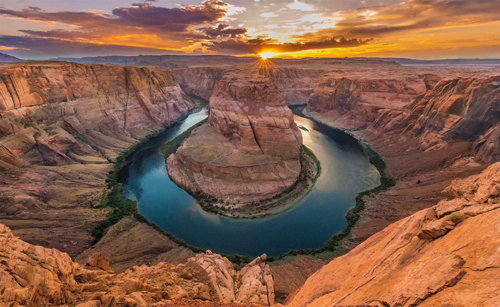
Horseshoe Bend earns its name honestly: the Colorado River curves back on itself so completely here that, seen from the rim, the water appears to nearly close into a full circle around a towering sandstone butte at its center. Few river bends anywhere in the world are quite this dramatic, and fewer still are so easily viewed from a single overlook a short walk from a parking area near Page, Arizona.
Scale is a large part of what makes the view so overwhelming in person. The rim sits roughly a thousand feet above the river below, and that vertical drop, combined with the sheer sweep of the meander itself, is difficult to fully appreciate in a photograph until you're standing at the edge looking down. The contrast of colors adds to the effect — deep blue-green water framed by warm orange and red sandstone, especially vivid in the low, angled light of early morning or evening.
That combination of scale, color, and an almost impossibly perfect curve is why Horseshoe Bend has become one of the most recognized and most photographed natural views in the American Southwest, rivaling far larger and more famous landscapes despite requiring only a short walk to reach.
Part of what makes the view so compelling is also how unexpected it is. Unlike the Grand Canyon, which announces its scale gradually as you approach the rim, Horseshoe Bend stays completely hidden until the very last few steps, when the flat, unremarkable slickrock underfoot suddenly gives way to a thousand-foot drop and the full sweep of the river comes into view all at once. That sudden reveal is part of the overlook's particular power, and it's a large part of why the view has become such an enduring symbol of this stretch of the Colorado River.
How Horseshoe Bend Was Formed
An Ancient Meandering River
Horseshoe Bend's dramatic curve did not begin as a canyon at all. Many millions of years ago, the ancestral Colorado River flowed across a much flatter landscape, and like any river moving across gentle terrain, it wandered naturally into loops and curves called meanders, carving a genuinely sinuous path back and forth across the land rather than a straight line.
Uplift and Incision
As the Colorado Plateau was gradually lifted over the following millions of years, the river's gradient steepened, and it began cutting downward into the rock beneath it with considerably more energy than before. Crucially, the river did this while largely preserving the winding path it had already established on the flatter landscape above — a process geologists call incision, in which a river entrenches itself directly into rising land rather than simply straightening its course.
Why the River Didn't Straighten Itself Out
It might seem more efficient for a river to abandon a sharp meander in favor of a straighter, shorter path, but the Colorado River's uplift here happened gradually enough, and the surrounding sandstone was uniform and resistant enough, that the river's original winding course simply cut straight down rather than shifting sideways. The result is what geologists call an entrenched or incised meander — a loop that would normally exist on a flat floodplain, instead preserved in dramatic relief within a deep canyon.
The Result Today
What visitors see at the overlook today is essentially a fossilized snapshot of an ancient river's wandering path, frozen in place and then carved a thousand feet deep by the same slow, patient uplift responsible for the Grand Canyon itself, farther downstream. For more on how this fits into the region's broader rock record, see our Arizona Geology → guide.
This same process, meander first, incision second, has produced similar entrenched curves at other points along the Colorado River and its tributaries across the plateau, though few are quite as dramatic, quite as complete, or quite as easily viewed from a single accessible overlook as the loop at Horseshoe Bend. The butte at the center of the bend, effectively an island of solid rock nearly surrounded by river on three sides, is itself a direct physical record of just how completely the ancient meander survived the uplift that eventually buried it in stone.
The Overlook and the Land
Reaching the Horseshoe Bend overlook involves a short walk across open, exposed slickrock from a nearby parking area — there is no lengthy hike involved, which is part of why the view has become so accessible and so widely photographed. That accessibility comes with real responsibility: the overlook sits at the edge of a genuine thousand-foot drop, and the terrain near the rim is uneven, sloped sandstone rather than a paved platform. A protective barrier was added along part of the rim in 2018 after a number of serious accidents, though much of the immediate area still demands the same caution appropriate to any unguarded cliff edge.
The land here reflects a genuinely layered set of jurisdictions. Horseshoe Bend and the surrounding river corridor lie within Glen Canyon National Recreation Area, managed by the National Park Service, while the trail and overlook itself sit on Navajo Nation land, and the parking area and approach are managed by the City of Page. That overlapping arrangement is a practical reflection of how much this part of northern Arizona brings together federal, tribal, and municipal land in a fairly small geographic area — and it's worth remembering, while visiting, that the ground beneath your feet at the rim itself belongs to the Navajo Nation.
This kind of shared jurisdiction is common across the Colorado Plateau, where reservation boundaries, national recreation areas, and municipal land often sit directly adjacent to one another, sometimes within the space of a single short trail. Rather than treating that complexity as a mere administrative footnote, it's worth understanding as a genuine reflection of the region's layered history — federal water and recreation infrastructure, a nearby city built to support that infrastructure, and Navajo homeland that predates all of it, each with a legitimate claim to a role in managing this particular stretch of canyon rim.
The Geology of Horseshoe Bend
Horseshoe Bend is carved into Navajo Sandstone, the same formation responsible for Antelope Canyon's flowing walls a few miles away, laid down as wind-blown sand dunes roughly 190 million years ago and later cemented into stone. Here, though, the sandstone has been shaped by an entirely different process — not the sudden, violent carving of flash floods through a narrow crack, but the slow, sustained cutting of a permanent river working steadily downward over millions of years as the Colorado Plateau rose beneath it.
That uplift is the same broad geological event responsible for the Grand Canyon itself, part of a regional pattern in which relatively gentle, even lifting of the Colorado Plateau allowed rivers across the region to cut deep, dramatic canyons while leaving the surrounding rock layers largely undisturbed and clearly readable. Erosion, flash flooding in side washes, and the steady flow of the river itself all continue to shape the canyon today, even as its fundamental meandering shape, inherited from a much older, flatter landscape, remains essentially fixed in place.
The distinct blue-green color of the water itself has its own explanation, related to the Glen Canyon Dam a few miles upstream: water released from near the base of the dam is drawn from deep within Lake Powell, arriving cold, clear, and largely free of the suspended sediment that once gave the Colorado River its characteristic muddy red-brown color before the dam was built. For the fuller regional picture, see our Arizona Geology → guide.
This is worth pausing on, because it means the river visitors see at Horseshoe Bend today looks meaningfully different from the river that carved the canyon in the first place. For most of its geological history, the Colorado River here would have carried a heavy, visible load of red-brown sediment, the same material responsible for carving the canyon's sheer walls over millions of years. The clear, blue-green water visible today is a comparatively recent, dam-influenced condition, layered on top of a canyon shaped by a considerably muddier, more sediment-laden river across most of its geological history.
Why the Colors Change Throughout the Day
Horseshoe Bend looks noticeably different depending on when you see it, and the reasons are straightforward physics rather than any trick of photography. Around midday, with the sun high overhead, the canyon walls receive direct, relatively even light, producing a flatter, brighter palette of tan and orange sandstone against blue-green water.
Early morning and evening tell a different story. As the sun sits low near the horizon, its light travels through considerably more atmosphere before reaching the canyon, scattering shorter blue wavelengths and letting warmer red and orange wavelengths dominate — the same basic phenomenon responsible for any vivid sunrise or sunset, intensified here by the sandstone's own naturally warm, iron-rich coloring. That low-angle light also rakes across the canyon walls at a steep side angle rather than a direct overhead one, throwing deep shadows that emphasize the sandstone's texture and layering far more dramatically than midday light does.
The water's blue-green color remains relatively constant across the day, since it results from mineral content and depth rather than surface lighting alone, but even it shifts subtly in tone as the surrounding light changes, appearing deeper and more saturated under the warm light of early morning and evening than it does under the flatter light of midday.
Weather adds its own variation on top of this daily cycle. Clear skies produce the cleanest, most saturated color contrast between water and stone, while scattered clouds can filter and soften the light considerably, sometimes producing a more muted, diffused palette across the entire canyon. Dust or haze in the atmosphere, common during particularly dry or windy stretches of weather, can likewise mute colors that would otherwise appear sharp and saturated under cleaner air — one more way that ordinary atmospheric conditions, rather than anything happening within the canyon itself, shape what any given visitor actually sees.
How an Incised Meander Forms
Horseshoe Bend's dramatic loop is a direct result of a process that unfolded over many millions of years, in a sequence worth understanding stage by stage.
| Stage | What Happens |
|---|
| A river meanders across flat land | The ancestral Colorado River winds naturally across a low-gradient landscape. |
| The land begins to rise | Gradual uplift of the Colorado Plateau steepens the river's gradient. |
| The river cuts downward | Rather than straightening, the river entrenches into the rising rock along its existing path. |
| The meander is preserved | The original winding shape is carved into solid stone rather than erased. |
| A deep, curved canyon remains | Horseshoe Bend's near-360-degree loop is the visible result today. |
That sequence explains why Horseshoe Bend looks the way it does: not a canyon carved in a straight line by a river seeking the shortest path, but a genuinely ancient wandering path, preserved in dramatic relief by a landscape that rose beneath it.
Two Landscapes, Two Kinds of Erosion
Horseshoe Bend and Antelope Canyon sit only a few miles apart and share the same Navajo Sandstone, yet they look nothing alike — a difference that comes down entirely to how each was carved.
| Feature | Antelope Canyon | Horseshoe Bend |
|---|
| Carved by | Flash floods through a narrow crack | A permanent river cutting downward over millions of years |
| Erosion style | Sudden, episodic, from within a crack | Slow, continuous, from the surface down |
| Resulting shape | Narrow, flowing, curved slot passageways | A single, sweeping open river meander |
| Defining feature | Reflected, colorful light | Scale and the dramatic curve itself |
Seen together, the two landscapes offer a genuinely useful lesson in geology: the same sandstone, shaped by two entirely different kinds of water erosion, produces two of the most visually distinct landscapes in the entire Southwest.
Wildlife Around Horseshoe Bend
The high-desert plateau surrounding Horseshoe Bend supports a resilient community of plants and animals adapted to intense sun, minimal rainfall, and exposed sandstone terrain. Hardy desert shrubs and grasses take hold in the thin soil atop the rim, while the sheer canyon walls below offer little purchase for vegetation of any kind.
Desert bighorn sheep are occasionally spotted navigating the steep canyon terrain along the river corridor, remarkably well adapted to terrain that would be impassable for most other large mammals. Ravens are a near-constant presence overhead, riding the thermal air currents that rise off the sun-warmed canyon walls, while raptors including red-tailed hawks patrol the open sky above the rim in search of smaller prey. For a closer look at the animals found throughout the wider region, see our full Arizona Wildlife → guide.
The river corridor below the rim, cooler and more sheltered than the exposed plateau above, supports a somewhat different mix of life than the surrounding high desert, including waterfowl and other birds drawn to the reliable water the dam-regulated river now provides year-round. That contrast between the stark, exposed rim and the more sheltered river corridor far below is itself a small-scale echo of the same ecological pattern found throughout much of the canyon country of the Colorado Plateau.
Horseshoe Bend Through the Seasons
Spring
Spring brings comfortable temperatures and increasingly long daylight hours, with clear desert light well suited to viewing the full sweep of the canyon below.
Summer
Summer brings intense heat across the exposed slickrock approach to the overlook, along with the region's monsoon season, when afternoon thunderstorms can build quickly over the plateau. Long daylight hours make both early morning and evening visits practical during this season.
Fall
Fall typically offers some of the most comfortable conditions of the year, with stable weather and warm, clear light well suited to the canyon's naturally vivid color palette.
Winter
Winter brings cooler temperatures, fewer visitors, and a lower sun angle that changes the quality and duration of the warm, low-angle light that makes the canyon walls glow most vividly.
Protecting Horseshoe Bend for Future Generations
Horseshoe Bend's popularity has grown enormously over the past two decades, and that popularity carries real consequences for a landscape that is, in several important ways, quite fragile. Foot traffic across the exposed slickrock approach has visibly widened informal paths over the years, and the cliff edge itself demands a level of caution that a short, easy walk from a parking lot doesn't always prompt in visitors who arrive expecting a fully developed, guardrailed overlook.
Shared stewardship between the National Park Service, the Navajo Nation, and the City of Page reflects a genuine, ongoing effort to balance public access with the practical realities of protecting both visitor safety and the landscape itself. Staying on established paths, respecting any posted barriers or guidance, and treating the cliff edge with serious caution are not simply suggestions — they are what allow a landscape this popular, and this genuinely hazardous at its edges, to remain safely open to the public at all.
Because part of the overlook sits on Navajo Nation land, visiting respectfully also means recognizing that this is not simply a scenic pull-off, but a place with the same claim to respectful treatment as any other part of the Navajo homeland. Conservation here, as elsewhere across the Colorado Plateau, is ultimately about ensuring that a view this extraordinary remains available, and remains safe, for generations of visitors still to come.
Horseshoe Bend and the Colorado Plateau
Horseshoe Bend is one chapter in the same immense geological story that shaped the Grand Canyon, Antelope Canyon, and much of the Southwest's most celebrated scenery. All of it traces back to the Colorado Plateau, the vast, uplifted region of layered rock spanning parts of Arizona, Utah, Colorado, and New Mexico.
Grand Canyon
Nearly two billion years of exposed rock layers, carved by the Colorado River.
↓
Antelope Canyon
Navajo Sandstone carved by flash floods into flowing slot canyon walls.
↓
Horseshoe Bend
An ancient river meander preserved in a thousand-foot-deep incised canyon.
↓
Vermilion Cliffs
Towering, colorful sandstone escarpments marking the edge of the plateau.
↓
Painted Desert
Colorful badlands revealing older rock layers exposed by erosion.
↓
Colorado Plateau
The vast uplifted region connecting all of these landscapes into one story.
Understood this way, Horseshoe Bend is more than a striking photograph — it's physical evidence of an ancient river's wandering path, preserved by the same slow uplift that carved the Grand Canyon itself. For the full regional picture, see our Colorado Plateau → guide.
Interesting Facts About Horseshoe Bend
- Horseshoe Bend is an incised meander, an ancient river curve preserved as the land rose beneath it.
- The overlook sits roughly a thousand feet above the Colorado River.
- The trail and overlook lie on Navajo Nation land within Glen Canyon National Recreation Area.
- The river's blue-green color comes from cold, clear water released near the base of Glen Canyon Dam.
- A protective barrier was added along part of the rim in 2018 to improve visitor safety.
Frequently Asked Questions
What is Horseshoe Bend?
Horseshoe Bend is a dramatic, near-360-degree curve of the Colorado River, viewed from a cliff roughly a thousand feet above the water near Page, Arizona.
How was it formed?
It formed as an ancient meandering river cut downward into rising land during the uplift of the Colorado Plateau, preserving its original winding path as a deep, entrenched canyon rather than straightening out.
Why is it called Horseshoe Bend?
The name describes the shape of the river itself, which curves back on itself so completely that it nearly forms a closed loop resembling a horseshoe around a central sandstone butte.
Where is it located?
Horseshoe Bend is located a few miles south of Glen Canyon Dam near Page, Arizona, within Glen Canyon National Recreation Area and on Navajo Nation land.
Why is the water so blue-green?
The color comes from cold, clear water released near the base of Glen Canyon Dam, drawn from deep within Lake Powell and largely free of the sediment that once gave this stretch of the Colorado River a muddier color.
Is Horseshoe Bend on Navajo Nation land?
Yes, in part — the trail and overlook sit on Navajo Nation land, while the surrounding river corridor lies within Glen Canyon National Recreation Area and the parking area is managed by the City of Page.
How difficult is the walk to the overlook?
The walk from the parking area to the rim is short but crosses open, exposed slickrock with real elevation change and a genuine cliff edge, requiring caution regardless of its short distance.
How is Horseshoe Bend different from Antelope Canyon?
Both are carved from the same Navajo Sandstone, but Antelope Canyon was cut by flash floods through a narrow crack, while Horseshoe Bend was carved by a permanent river slowly entrenching into rising land over millions of years.
Continue Exploring Arizona
Horseshoe Bend connects to a wider network of extraordinary landscapes across northern Arizona and the Colorado Plateau. Here's where to go next:
Antelope Canyon
A world-famous slot canyon a few miles away.
READ GUIDE →Lake Powell
A vast reservoir amid dramatic sandstone canyon country.
READ GUIDE →Grand Canyon National Park
The centerpiece of Arizona's geological story.
READ GUIDE →Navajo Nation
The largest Native American reservation in the United States.
READ GUIDE →Colorado Plateau
The vast geological region connecting Arizona's iconic landscapes.
READ GUIDE →
Discover Arizona's Natural Wonders with Grand Canyon Journeys
Horseshoe Bend is one of Arizona's most extraordinary natural wonders, where geology, scale, and the surrounding Navajo homeland come together to create an unforgettable view. Our private Arizona experiences help guests discover the remarkable diversity of Northern Arizona while encouraging respectful appreciation of the places and communities that make this region so special.
Secret Antelope Canyon & Horseshoe Bend Tour
From $419
VIEW TOUR →