Sunset Crater Volcano National Monument at a Glance
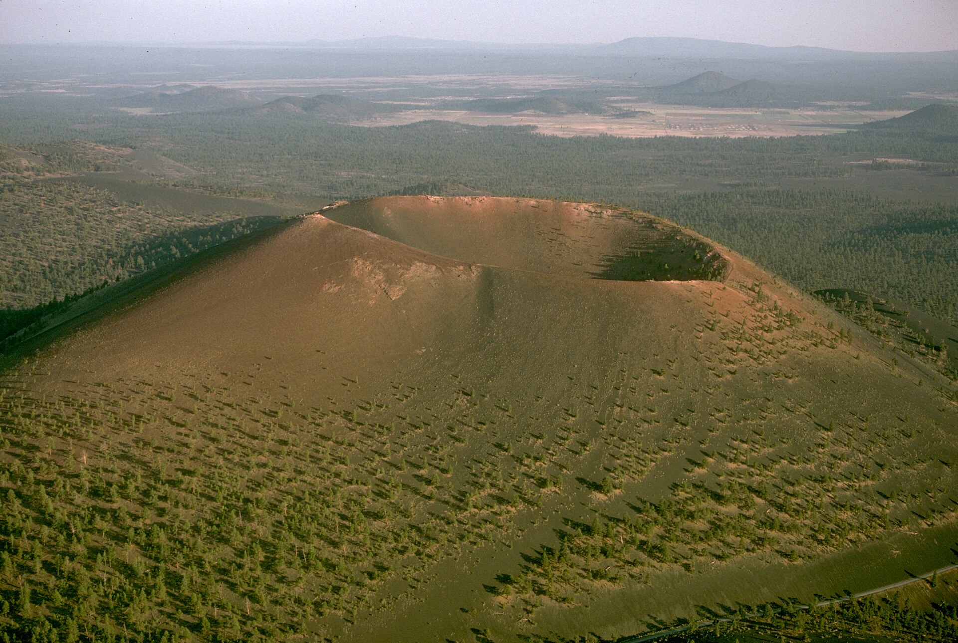
Just north of Flagstaff, a black cinder cone rises out of the ponderosa pine forest — the youngest volcano in a field of hundreds. Sunset Crater Volcano National Monument protects the site of a dramatic eruption that reshaped the land and the lives of the people living on it, leaving behind a landscape that, geologically speaking, still looks almost brand new. Before diving into the details, here's the monument at a glance:
Located North of Flagstaff
Northern Arizona
Protected National Monument
Managed by the National Park Service
One of Arizona's Youngest Volcanoes
A geological newcomer
Erupted ~900 Years Ago
Around 1085 CE
San Francisco Volcanic Field
Part of a field of 600+ volcanic features
National Park Service Site
Preserved for research and visitation
Why Visit Sunset Crater Volcano National Monument?
It's easy to drive past a cinder cone without a second thought — until you understand what you're actually looking at. Sunset Crater rewards visitors who slow down and look closely, whether that means tracing a lava flow's rippled surface or simply noticing how sharply the black cinder contrasts against green pine forest. Here's what makes Sunset Crater worth the stop:
Volcanic Landscapes
A black, cratered terrain unlike anywhere else in Arizona, still looking freshly formed after nearly a thousand years.
Lava Fields
Jagged rivers of hardened rock frozen mid-flow, preserved almost exactly as they cooled.
Cinder Cones
A textbook example of how a volcano builds itself, layer by layer, from its own erupted debris.
Scenic Beauty
Ponderosa pine forest framing a stark black cone — one of the more striking contrasts in the Southwest.
Geological Importance
One of the best-preserved and most accessible young volcanoes in the continental United States.
Wildlife
Elk, mule deer, and forest birds move through a landscape still recovering from volcanic disruption.
Photography
Black cinder, green pine, and red-orange summit color make for some of Northern Arizona's most graphic compositions.
History
A rare place where geology and human history intersect in a single, well-documented event.
The Eruption That Changed Northern Arizona
The Birth of Sunset Crater
Sometime around 1085 CE, the ground near modern-day Flagstaff split open along a volcanic fissure. Molten rock blasted skyward in a fountain of gas and fragmented lava, cooling into cinders as it fell back to earth and piling up around the vent. Layer by layer, that falling debris built the steep, symmetrical cone that stands today — a process that likely took months to a few years, remarkably fast for a landform that size. As the eruption continued, thick basaltic lava also broke out from the base of the cone, spreading across the surrounding land in slow-moving, rubble-covered flows. By the time the activity finally stopped, the eruption had built a cone roughly 1,000 feet high and left behind a scarred, blackened landscape that would take centuries to soften. Geologists studying the site have identified several distinct eruptive phases within that broader event, meaning the eruption likely wasn't one continuous outburst but a series of pulses — periods of intense activity separated by quieter stretches, each adding another layer to the growing cone.
Life Before the Eruption
The area wasn't empty when the volcano erupted. Ancestral Puebloan communities were already farming the region, growing corn, beans, and squash in the high-desert soil around what is now Wupatki and the Flagstaff area. Small, scattered settlements dotted the landscape, relying on seasonal rainfall and careful land use to farm at an elevation and in a climate that left little room for error. Archaeological evidence suggests these communities had lived in the region for generations before the eruption, developing farming techniques suited to the area's thin soils and unpredictable moisture. Excavations near the monument have uncovered pit houses and farming tools dating to this period, painting a picture of a settled, established way of life rather than a transient or sparse population.
How the Eruption Changed the Landscape
The eruption buried nearby land under lava and thick layers of black cinder ash, forcing existing communities to leave the immediately affected areas. But the story isn't simply one of destruction — the same volcanic ash, spread over a much wider area by wind, acted as a natural mulch that helped retain soil moisture, and in the years that followed, it appears to have made farming possible across a larger area than before, including at higher, previously marginal elevations. New ecosystems slowly took hold on the cooled lava and cinder fields, starting with hardy pioneer plants and gradually building toward the ponderosa pine forest that covers much of the area today. The region's agricultural patterns shifted in ways that shaped the centuries that followed, drawing new settlement into areas that hadn't previously supported it. It's a pattern researchers have observed at other volcanic sites around the world — in the right conditions, the same ash that displaces a community in the short term can make the surrounding land more productive for generations afterward.
Timeline of the Eruption
The eruption wasn't just a geological event — it changed the lives of the people already living in the region. Seeing it laid out step by step helps make sense of how a single volcanic event could ripple outward into decades of agricultural and cultural change. Here's how it unfolded:
1,000+ Years Ago
↓
Thriving Indigenous Communities
↓
Volcanic Activity Begins
↓
Major Eruption
↓
Ash Covers the Region
↓
Lava Flows Reshape the Landscape
↓
Agriculture Adapts
↓
Present Day National Monument
Geology of Sunset Crater
The San Francisco Volcanic Field
Sunset Crater is one feature within the San Francisco Volcanic Field, a vast field of more than 600 volcanic vents spread across roughly 1,800 square miles of Northern Arizona, built up over the past six million years. The field's centerpiece, the San Francisco Peaks near Flagstaff, is itself the eroded remnant of a much older, larger volcano that likely once stood far taller than the peaks visible today. Sunset Crater, by contrast, is the field's youngest feature by a wide margin — a geological newcomer in a landscape shaped by millions of years of eruptions, and a rare chance to see what the field's much older, more eroded volcanoes would have looked like when they were new.
Cinder Cone Volcanoes
Sunset Crater is a classic cinder cone — a simple, steep-sided volcano built entirely from erupted fragments of lava called cinders, or scoria. Unlike the broad, sprawling shape of a shield volcano, or the tall, layered profile of a stratovolcano, cinder cones form quickly and hold their conical shape well after the eruption ends, which is part of why Sunset Crater still looks so strikingly fresh nearly a thousand years later. Most cinder cones like this one erupt only once in their lifetime, building their cone in a single sustained event and then falling permanently dormant — a pattern that appears to hold true for Sunset Crater as well.
Lava Flows
Two major lava flows, known as the Kana-a flow and the Bonito flow, erupted from the base of the cone and spread across the surrounding land, together covering several square miles. Both are still clearly visible today as jagged, dark fields of hardened rock, largely unsoftened by nearly a millennium of weathering — a reminder of just how recently, geologically speaking, this landscape formed. Walking along the edge of these flows, it's easy to see individual ripples and pressure ridges frozen in the rock, exactly as they moved in the final moments before the lava cooled solid.
Volcanic Rock
The dominant rock at Sunset Crater is basalt, a dark, iron-rich volcanic rock that cools quickly at the surface. Much of it is preserved as rough, blocky a'a lava — a jumble of sharp, broken rock fragments that formed as the surface of the flow cooled and cracked while the still-molten lava beneath kept moving, shoving the broken crust forward like rubble ahead of a slow-moving bulldozer. This rough surface texture is one reason the lava fields still look so raw and undisturbed — a'a lava is notoriously slow to break down and support plant life, even after centuries of exposure.
The Colorful Summit
The crater's name comes from its summit, where oxidized iron in the volcanic cinders creates a band of red, orange, and yellow that looks like a permanent sunset glow, especially vivid in early morning and late afternoon light. Those colors come from the same basic chemistry as rust: iron minerals in the cinders reacted with oxygen and volcanic gases during and after the eruption, staining the rock in warm tones that remain vivid centuries later.
Did You Know?
- 🌋 Sunset Crater is one of more than 600 volcanic features in the San Francisco Volcanic Field.
- 🌋 Although called "Sunset Crater," the volcano is considered dormant, not extinct. Scientists continue to study the volcanic field because future eruptions are possible somewhere within it over geologic timescales, though there is no indication of an imminent eruption.
- 🌋 The monument protects not only volcanic features but also forests, wildlife, and archaeological resources.
- 🌋 Climbing to the summit is no longer allowed, protecting both the fragile cinder slopes and the delicate colors that give the crater its name.
Taken together, these five elements — the field it belongs to, the way it formed, the flows it produced, the rock it's made of, and the colors at its summit — turn what looks at first like a simple black hill into one of the more legible volcanic stories in the American Southwest.
Wildlife and Plant Life
Nearly a thousand years after the eruption, life has steadily reclaimed the volcanic landscape, though not evenly. Tall ponderosa pine forests now surround the cinder fields, with wildflowers taking hold in the more established soil pockets each spring — look for penstemon, lupine, and Indian paintbrush adding color to the black cinder ground in May and June. Elk and mule deer move through the area regularly, especially around dawn and dusk, often visible from the main park road. A variety of birds and small mammals have adapted to a terrain that's still, in geological terms, remarkably young, including pinyon jays, mountain chickadees, and the occasional golden eagle riding thermals above the cone.
In the most recently disturbed areas near the crater itself, plant life remains sparse — a visible reminder of how slowly ecosystems rebuild on raw volcanic ground, even after nearly a millennium. Botanists studying the site have documented a clear gradient of plant recovery, from nearly bare cinder near the summit to fully established forest at the field's edges, making Sunset Crater a useful living laboratory for understanding how ecosystems recover after a volcanic disturbance.
For a closer look at the animals found throughout the region, see our full Arizona Wildlife → guide.
Indigenous History
The eruption of Sunset Crater is inseparable from the human history of the region. Ancestral Puebloan communities were living and farming in the area when the volcano erupted, and the event directly reshaped their world. Archaeologists studying the site have found evidence of settlements that were active in the years immediately before the eruption, giving researchers an unusually clear before-and-after picture of how a community responded to a major volcanic event.
In the immediate aftermath, communities closest to the eruption were forced to relocate. But the volcanic ash that spread across a much wider area appears to have improved farming conditions in parts of the surrounding high desert, helping the soil retain moisture in an otherwise arid climate. In the decades that followed, the region saw a notable increase in settlement, including the communities that would go on to build the structures preserved today at nearby Wupatki National Monument. Population in the wider region appears to have grown substantially in the century after the eruption, suggesting that, for many families, the changed landscape ultimately became more hospitable to farming than it had been before.
This is a case of genuine adaptation and resilience — communities responding to a major natural event by reshaping where and how they farmed and lived, not a story of catastrophe alone. The descendants of these communities, including the Hopi and other regional tribes, maintain cultural and historical connections to this landscape today, and tribal historians continue to be involved in how the National Park Service interprets and protects the site. We present this history as it's documented by archaeologists and tribal historians, without speculation about specific ceremonies or beliefs that aren't part of the public record.
Sunset Crater Through the Seasons
Spring
Wildflowers begin appearing in the pockets of soil between cinder fields, and cool, comfortable temperatures make the Lava Flow Trail especially pleasant to walk. Snow can still linger into April at this elevation, so early spring visitors should check trail conditions before heading out.
Summer
The surrounding ponderosa pine forest is at its greenest, though afternoon thunderstorms are common through the monsoon season, so a morning visit is usually the more comfortable choice — both for weather and for avoiding the exposed, shadeless heat of the cinder fields by midday.
Fall
Aspens turn gold in pockets around the wider San Francisco Volcanic Field, pairing crisp, cool temperatures with some of the best light of the year for photographing the crater's cinder slopes. Crowds thin out considerably compared to summer, making it one of the more peaceful times to visit.
Winter
Snow dusting the black volcanic rock creates one of Arizona's most unusual winter landscapes — a striking contrast of white snow, dark cinder, and the crater's warm-toned summit. The visitor center and main park road typically stay open, though some trails may be icy or snow-covered, so sturdy footwear is worth packing.
Interesting Facts About Sunset Crater
A handful of details tend to surprise first-time visitors most:
- One of the youngest volcanoes in the continental United States, and by far the youngest in its own volcanic field.
- The eruption may have lasted months to years, not a single dramatic event, building the cone gradually rather than all at once.
- Volcanic ash improved farming conditions in some surrounding areas, rather than only causing harm, by helping retain scarce moisture in the soil.
- Part of a volcanic field with hundreds of volcanic features, spanning roughly 1,800 square miles of Northern Arizona.
- The crater gets its name from the colorful red and orange oxidized cinders near its summit, first noted by explorer John Wesley Powell.
- Climbing the cinder cone itself is no longer permitted, in order to protect the fragile slopes from erosion — the Lava Flow Trail is the primary way to experience the volcanic landscape up close today.
Sunset Crater and Wupatki
Sunset Crater doesn't stand alone in the story of Northern Arizona — it's directly connected to nearby Wupatki National Monument, just a short drive across the same volcanic field. The ash from the eruption spread across the land that would become Wupatki, and in the years and decades that followed, communities adapted to the changed landscape, in some cases settling the area in greater numbers than before. The red sandstone pueblos preserved at Wupatki today were built by people whose farming lives had been reshaped by this very eruption, and archaeologists consider the two sites part of a single, connected story rather than two unrelated attractions that simply happen to sit near each other.
Because both monuments are managed together and connected by the same 34-mile scenic loop road north of Flagstaff, they're easy to visit in a single trip — and doing so gives a far more complete picture than seeing either one alone.
Visiting both sites together tells a more complete story than either can alone: Sunset Crater shows you the eruption itself, and Wupatki shows you how people responded to it. To continue the story, visit Wupatki National Monument →.
Frequently Asked Questions
How old is Sunset Crater?
Sunset Crater erupted approximately 900 years ago, around 1085 CE, based on tree-ring dating of trees that were buried or singed by the eruption's lava and ash — one of the more precisely dated eruptions of its kind anywhere in North America.
Is it still active?
Sunset Crater itself hasn't erupted since its original eruption nearly 900 years ago. It's considered dormant rather than extinct, as part of a volcanic field that remains geologically active over long timescales, even though no single vent within it has erupted in nearly a millennium.
Can the volcano erupt again?
Scientists don't expect an imminent eruption, but because Sunset Crater is part of the still-active San Francisco Volcanic Field, future volcanic activity remains possible somewhere within the field over geologic timescales — there is currently no indication that this is imminent. Given that most vents in the field erupt only once, any future activity would likely occur at a new location rather than at Sunset Crater itself.
Why is it called Sunset Crater?
Explorer John Wesley Powell named it in 1892 for the way sunlight strikes the oxidized red and orange cinders near its summit, giving the impression of a permanent sunset glow on the mountain, regardless of the time of day.
What type of volcano is it?
Sunset Crater is a cinder cone volcano — a steep, cone-shaped hill built up from erupted fragments of lava, rather than a broad shield volcano or a tall stratovolcano. It's one of the most accessible, well-preserved examples of this type of volcano in the country.
How large is the monument?
Sunset Crater Volcano National Monument protects roughly 3,040 acres of volcanic landscape just north of Flagstaff, including the cone itself, both major lava flows, and the surrounding forest.
Is it worth visiting?
Yes — especially paired with nearby Wupatki National Monument. Few places let you see a volcanic eruption and its direct human impact this clearly, in a landscape that still looks remarkably fresh nearly a thousand years later.
What makes it unique?
Its age, more than anything else. Most volcanic landscapes people visit are millions of years old and heavily eroded; Sunset Crater is young enough that its cinder cone, lava flows, and even the human response to the eruption are all still clearly preserved and legible on the land, making it as much a history lesson as a geology lesson.
Continue Exploring Arizona
Sunset Crater is just one piece of Northern Arizona's volcanic and ancestral story. Here's where to go next:
Wupatki National Monument
How communities adapted to the eruption's ash-covered landscape.
READ GUIDE →Walnut Canyon National Monument
Ancient cliff dwellings tucked into a forested limestone canyon.
READ GUIDE →Petrified Forest National Park
Fossilized, rainbow-colored ancient trees across northeastern Arizona.
READ GUIDE →Grand Canyon National Park
The centerpiece of any Arizona trip, carved across nearly two billion years.
READ GUIDE →Arizona Geology
The volcanic and geological forces that shaped the entire state.
READ GUIDE →
Discover Arizona's Volcanic Landscapes with Grand Canyon Journeys
Sunset Crater Volcano National Monument offers one of the most fascinating geological stories in Arizona. Combined with nearby Wupatki National Monument and the landscapes surrounding Flagstaff, it provides a deeper understanding of how volcanic forces shaped Northern Arizona. Our private tours help guests connect these remarkable places through engaging stories, history, and local knowledge.
Whether you're drawn in by the geology, the history, or simply the striking contrast of black cinder against green pine forest, Sunset Crater offers a rare, close-up look at how quickly — and how completely — a landscape and the people living on it can change.