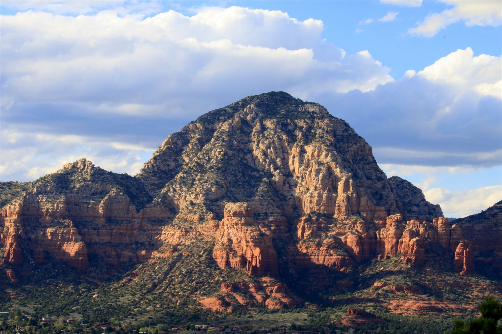
Sedona at a Glance
Tucked at the mouth of Oak Creek Canyon in Northern Arizona, Sedona is defined by towering red rock formations, a mild four-season climate, and a setting that has drawn artists, adventurers, and travelers from around the world for generations. Before learning more about what makes Sedona so extraordinary, here's an overview at a glance:
Located in Northern Arizona
At the mouth of Oak Creek Canyon
Roughly 4,350 Feet Elevation
Cooler than the low desert
A Small, Vibrant City
With an outsized creative and cultural presence
Famous Red Rock Formations
Cathedral Rock, Bell Rock, and more
A Mild Four-Season Climate
Enjoyable nearly year-round
An Ideal Northern Arizona Base
Close to the Grand Canyon and Verde Valley
Why Visit Sedona?
Few destinations in Arizona, or the wider Southwest, pack quite so much into a single small city. Sedona's defining feature is its scenery — towering red sandstone formations rising directly from the desert floor, arranged with a drama and density found almost nowhere else, framed by the deep green of Coconino National Forest and the winding, water-carved corridor of Oak Creek Canyon. That scenery alone would be enough to justify a visit, but Sedona layers considerably more on top of it.
Outdoor recreation, scenic drives, and photography opportunities are built directly into the landscape, while a genuinely significant arts community, decades in the making, has filled the city with galleries, studios, and public art. Restaurants and luxury accommodations serve a level of hospitality well beyond what a city of Sedona's modest size would typically support, reflecting decades of investment in tourism as a core part of the local economy. Clear, dark night skies, protected in part by local lighting ordinances, make Sedona a genuinely excellent place for stargazing, a quieter but increasingly appreciated part of its appeal.
Scenic drives connecting Sedona to the surrounding landscape add yet another dimension to a visit, from the switchbacks of Oak Creek Canyon to the open red rock vistas along Highway 179 toward the Village of Oak Creek. Few American towns of Sedona's size offer such an unbroken run of dramatic scenery in every direction from the town center, a fact that becomes obvious within minutes of arriving regardless of which direction you happen to be traveling.
Perhaps most practically, Sedona's central location within Northern Arizona makes it an unusually convenient base for exploring considerably farther afield — a theme this guide returns to in detail below, since it may be the single most important reason to consider Sedona as more than just a standalone destination.
Photography deserves particular mention on its own terms. Few places in Arizona offer such a dense concentration of dramatic, easily accessible viewpoints, and the region's naturally warm sandstone responds to changing light in ways that reward visitors who return to the same formation at different times of day. That same quality of light, and the clean desert air that carries it, is also part of why Sedona has become such a respected setting for landscape photographers and casual visitors alike, regardless of experience level or equipment.
Wellness and outdoor recreation have also become closely associated with Sedona over recent decades, from hiking and mountain biking across the surrounding red rock terrain to a broader wellness tourism industry that has grown alongside the area's reputation for natural beauty and tranquility. Whatever draws a particular visitor to Sedona, the surrounding red rock landscape tends to remain the constant thread running through nearly every experience the town has to offer.
The Story of Sedona
Early Indigenous History
Long before Sedona existed as a town, the Sinagua people lived throughout the Verde Valley and the red rock country surrounding present-day Sedona, farming the region's canyons and building the cliff dwellings and pueblos still preserved today at nearby Montezuma Castle, Tuzigoot, and Walnut Canyon. The Yavapai and Apache peoples also have deep historical ties to this landscape, with the Yavapai-Apache Nation maintaining a continued presence in the Verde Valley today. For all of these communities, the region's dramatic red rock formations carried, and continue to carry, significant cultural and spiritual meaning, understood as far more than simply striking scenery.
Oak Creek itself was central to that early presence, offering a rare, dependable water source in a landscape otherwise defined by aridity. That same practical advantage, reliable water framed by defensible, dramatic terrain, shaped patterns of settlement in this specific valley for many centuries before any American town existed here, and it remains just as central to Sedona's identity and appeal today.
Archaeological sites throughout the broader Sedona and Verde Valley area, including cliff dwellings, pit houses, and agricultural terraces, document a sustained Sinagua presence here across several centuries, before the community gradually dispersed or merged with neighboring peoples by the 1400s, for reasons that remain the subject of ongoing archaeological study. That long, layered history is easy to overlook amid Sedona's modern tourism identity, but it represents by far the longest chapter of continuous human presence in this particular landscape.
Pioneer Settlement
American settlement of the Sedona area began in the late 1800s, as small numbers of ranching families moved into the Oak Creek Canyon area, drawn by the reliable water and fertile bottomland the creek provided in an otherwise arid region. The town itself takes its name from Sedona Schnebly, an early settler whose husband, Theodore Carlton Schnebly, established the town's first post office in 1902 and submitted her name for the new community rather than one of the more conventional options originally proposed. Ranching and small-scale farming sustained the growing community through the early 20th century, long before tourism became the area's defining economic activity.
Early Sedona remained a genuinely small, isolated agricultural community for decades, connected to the outside world by rough, often difficult roads through Oak Creek Canyon. That isolation began to change gradually through the early-to-mid 20th century, as improved roads and growing regional tourism started drawing visitors specifically to see the red rock scenery that local ranching families had lived among, largely unremarked upon by the outside world, for generations.
Sedona Today
Tourism transformed Sedona over the course of the 20th century, drawn initially by the same dramatic red rock scenery that continues to define the city's identity today, and later reinforced by a growing arts community and a reputation for outdoor recreation. Modern Sedona balances a genuinely significant tourism economy with an active arts scene, a range of outdoor recreation opportunities, and a strong local emphasis on luxury hospitality, all layered on top of a permanent community considerably smaller than the numbers of annual visitors might suggest.
That balance is not always simple to maintain. Sedona's popularity brings real questions about traffic, land management, and sustainable tourism that the local community continues to actively navigate, including local efforts around trail management, transit, and protecting the same natural landscape that draws visitors in the first place. Understanding Sedona today means recognizing it as a living, working community managing real growth pressures, not simply a scenic backdrop for visitors passing through.
The surrounding Coconino National Forest plays a significant role in this balance, managing the public land that borders much of the town and provides access to many of the area's most popular trails and viewpoints. That shared boundary between private, municipal, and federal forest land shapes much of how Sedona manages growth today, requiring ongoing coordination between the city and federal land managers to balance public access with genuine conservation of the landscape both depend on.
The Famous Red Rocks
Sedona's formations are not a single continuous ridge but a collection of individually distinct buttes, spires, and mesas, each with its own name, shape, and character, scattered across the red rock basin surrounding the town. Many have earned informal names based on their resemblance to familiar shapes, a naming tradition that reflects generations of local residents and visitors alike finding their own way to relate to this genuinely singular landscape.
How the Red Rocks Were Formed
Sedona's red rock formations are built primarily from the Schnebly Hill Formation, layers of sandstone deposited by ancient rivers and windblown dunes roughly 275 to 300 million years ago, later exposed and sculpted by many millions of years of erosion following the broader uplift of the Colorado Plateau. That erosion carved the isolated buttes, spires, and mesas visible around Sedona today, each one a remnant of rock left standing after the softer surrounding material wore away.
Beneath the Schnebly Hill Formation's red sandstone, older, pale limestone and sandstone layers are visible in places, particularly along the walls of Oak Creek Canyon, recording still-earlier chapters of the same long geological story. Above the red sandstone, a resistant white-gray cap of Coconino Sandstone protects many of Sedona's formations from erosion that would otherwise wear them down considerably faster, helping preserve their dramatic height and shape.
Why They Are Red
The formations' distinctive red-orange color comes from iron oxide, essentially the same chemical process as rust, coating individual sand grains within the sandstone. That iron oxide coating was deposited as the sandstone formed and has remained stable for hundreds of millions of years since, intensifying in visual impact particularly at sunrise and sunset, when low-angle light interacts with the naturally warm base color of the stone.
Variation in iron content and concentration from one rock layer to the next produces the banding and color variation visible across many formations, ranging from deep orange-red to a paler, almost pink tone depending on the specific mineral content of each individual layer — a visible record of subtly different conditions at the time each layer was originally deposited.
Cathedral Rock
Among the most photographed formations in all of Arizona, Cathedral Rock's dramatic spires rise above Oak Creek, their reflection a defining image of Sedona itself. Its distinctive multi-spired silhouette, visible from many points around the Sedona area, has made it perhaps the single most recognizable formation in the entire red rock region.
Bell Rock
Named for its distinctive, symmetrical bell-like shape, Bell Rock stands prominently along the highway corridor between Sedona and the Village of Oak Creek, easily recognized from a considerable distance. Its relatively isolated position, set somewhat apart from the surrounding terrain, makes its shape especially easy to appreciate from multiple angles.
Courthouse Butte
Rising directly beside Bell Rock, Courthouse Butte's broad, sheer-walled form provides a dramatic visual counterpoint to its more slender neighbor, together forming one of the most photographed formation pairings in the entire Sedona area.
Snoopy Rock
A formation whose silhouette, seen from the right angle, is often said to resemble a recognizable cartoon beagle lying on its back — a small, well-loved piece of local nicknaming layered onto a formation with a far longer geological history, and a good example of how Sedona's community has developed its own affectionate, informal relationship with the landscape surrounding it.
Coffee Pot Rock
Named for its resemblance to an old-fashioned coffee pot, complete with a spout-like protrusion, Coffee Pot Rock rises prominently above West Sedona, visible from much of the surrounding town and a familiar backdrop to daily life for many Sedona residents.
Oak Creek Canyon
Stretching north from Sedona toward Flagstaff, Oak Creek Canyon is a dramatically different landscape from the open red rock country surrounding the town itself — a narrow, forested canyon carved by a genuine, year-round creek, with towering cliff walls rising on either side. The canyon's geology reflects considerably older rock layers than Sedona's red rocks, exposing sedimentary layers that record a much longer span of Earth's history within a single dramatic roadside corridor.
Ponderosa pine, oak, and bigtooth maple line the canyon's cooler, wetter environment, supporting wildlife rarely seen in the drier country around Sedona itself, and producing some of Arizona's most vivid autumn color each fall. Oak Creek itself remains a reliable year-round water source, sustaining this rare riparian corridor and offering some of the most rewarding photography anywhere in the region, particularly where the creek reflects the surrounding canyon walls.
The drive through Oak Creek Canyon, connecting Sedona to Flagstaff, is itself considered one of the most scenic routes in Arizona, climbing steadily in elevation through a series of switchbacks that offer sweeping views back down the canyon before finally emerging onto the forested Colorado Plateau near Flagstaff. That elevation change, from roughly 4,300 feet in Sedona to nearly 7,000 feet at the canyon's northern rim, produces a genuinely dramatic shift in climate and vegetation over a comparatively short distance, moving from high desert to mountain forest in well under an hour.
Slide Rock, a natural rock chute formed where the creek slides across smooth, water-polished sandstone, remains one of the canyon's most distinctive natural features, a direct physical demonstration of the same water-driven erosion responsible for shaping so much of the surrounding landscape. Together, Oak Creek Canyon's geology, forest, and creek make it feel like an entirely different region from red rock Sedona just a few miles south, despite the two landscapes being part of the same connected geological story. For the full picture, see our dedicated Oak Creek Canyon → guide.
Sedona's Arts and Culture
Sedona's arts community developed steadily over the second half of the 20th century, drawn initially by the same dramatic light and scenery that continues to attract visitors today, and has since grown into one of the most significant concentrations of galleries and working artists anywhere in the Southwest. Tlaquepaque Arts and Crafts Village, built to evoke a traditional Mexican arts village, remains the anchor of Sedona's gallery scene, housing dozens of studios and shops within its shaded courtyards and archways.
Public art is woven throughout the city itself, and a genuinely active community of working painters, sculptors, and photographers continues to draw creative inspiration directly from the surrounding red rock landscape. Seasonal festivals celebrating visual arts, film, and music add to Sedona's cultural calendar throughout the year, reflecting a community that has built much of its identity, and a meaningful part of its economy, around sustained creative practice rather than tourism infrastructure alone.
The Chapel of the Holy Cross, built directly into the red rocks south of town in 1956, stands as one of Sedona's most distinctive architectural landmarks, its modernist concrete form rising dramatically from the surrounding sandstone. Beyond its architectural significance, the chapel reflects a broader pattern found throughout Sedona: a community that has consistently sought to build alongside its landscape rather than simply in front of it, treating the surrounding red rocks as an active creative and spiritual influence rather than passive scenery.
Sedona's identity as a center for spiritual and wellness-oriented travel developed alongside its more conventional arts and tourism economy, drawing visitors interested in meditation, healing arts, and a general sense of natural tranquility that many associate with the surrounding red rock landscape. Whatever one makes of that particular reputation, it has become a genuine and lasting part of how Sedona is perceived and experienced by many of the visitors who travel here each year, layered alongside its more straightforward identity as a scenic and artistic destination.
Wildlife Around Sedona
The high-desert and canyon country surrounding Sedona supports a genuinely varied mix of wildlife, shaped by the area's unusual range of elevation and habitat within a relatively small area. Javelina move through the brushy desert terrain in small family groups, while mule deer are a common sight at dawn and dusk across much of the surrounding landscape. Coyotes and bobcats both range through the area, generally staying well clear of populated areas but occasionally visible from a distance in the surrounding open country.
Roadrunners are a distinctive and frequently spotted resident of the lower desert terrain, while a wide range of birds, from canyon wrens to red-tailed hawks, make use of the varied habitat found across red rock country and Oak Creek Canyon alike. Juniper and pinyon pine dominate the drier slopes surrounding Sedona, giving way to denser pine and riparian forest within Oak Creek Canyon itself.
That range of habitat, from open high desert to shaded canyon riparian corridor, within a relatively compact area is part of what allows Sedona to support such a genuinely varied mix of wildlife. Species that would never overlap in a more uniform landscape find suitable habitat within a short distance of one another here, making the Sedona area a rewarding destination for casual wildlife observation as well as scenery.
Early morning and evening tend to offer the best opportunities for spotting wildlife around Sedona, as the desert heat of midday sends most animals into whatever shade or shelter they can find until temperatures ease later in the day. For a closer look at the animals found throughout the wider region, see our full Arizona Wildlife → guide.
Sedona Through the Seasons
Spring
Spring brings comfortable temperatures and a colorful bloom of desert wildflowers across the surrounding red rock country, making it one of the most pleasant times of year to be outdoors. Days lengthen steadily through the season, and the clear, mild conditions typical of spring make it a popular time for outdoor recreation of every kind.
Summer
Summer days can grow quite warm, though Sedona's elevation keeps temperatures noticeably milder than the low desert of Phoenix or Tucson, with cool evenings that offer welcome relief. Monsoon season brings dramatic afternoon thunderstorms and correspondingly dramatic skies across the red rocks, along with a real, if temporary, drop in temperature each time a storm moves through.
Fall
Fall is widely considered one of the best times to visit, with comfortable temperatures, stable weather, and vivid changing color, particularly within Oak Creek Canyon's deciduous forest, layered on top of the red rocks' year-round color. The combination of mild days, crisp evenings, and reliable weather makes fall a favorite season among both visitors and longtime residents alike.
Winter
Winter brings a quieter atmosphere and occasional light snowfall dusting the red rocks, producing a striking, relatively rare contrast between fresh snow and the formations' naturally warm color. Visitor numbers ease noticeably during winter months, offering a quieter, more contemplative way to experience the same dramatic scenery that draws considerably larger crowds during the busier spring and fall seasons.
Why Sedona Is Unlike Anywhere Else in Arizona
| Feature | Why It Makes Sedona Special |
|---|
| Red Rock Formations | Towering sandstone formations create one of the most recognizable landscapes in the Southwest. |
| Four-Season Climate | Mild weather makes Sedona enjoyable throughout the year. |
| Central Location | Excellent base for exploring the Grand Canyon, Verde Valley, Flagstaff, and other Northern Arizona destinations. |
| Arts & Culture | Home to galleries, studios, and a vibrant creative community. |
| Outdoor Recreation | Scenic landscapes provide opportunities for hiking, photography, and nature appreciation. |
| Dark Skies | Clear night skies make Sedona a wonderful place for stargazing. |
A Landscape Shaped by Time
Sedona's scenery is best understood not simply as beautiful, but as the visible result of an immense span of geological time, unfolding in a sequence that connects directly to the same story behind the Grand Canyon and much of the rest of the Colorado Plateau. Ancient seas and rivers deposited the sand and sediment that would eventually become the region's sandstone layers, laid down in stages separated by many millions of years and by dramatically different environmental conditions.
Later, the broad uplift of the Colorado Plateau lifted this entire region thousands of feet, steepening the grade of local streams and rivers and setting the stage for the erosion that followed. Erosion, driven by water, wind, and the region's own seasonal freeze-thaw cycles, gradually sculpted today's cliffs, mesas, and isolated buttes out of what was once a far more continuous layer of rock, carving away the softer material and leaving Sedona's iconic formations standing in relief. Iron minerals within the sandstone itself, oxidizing over these same vast stretches of time, gave the rock its striking, enduring red color.
Freeze-thaw cycles continue to play an active role in shaping Sedona's formations even today, as water seeps into small cracks in the sandstone, expands as it freezes on cold winter nights, and gradually widens those cracks over repeated cycles across many years. Combined with the ongoing effects of wind and occasional heavy rainfall, this means Sedona's red rocks, much like Antelope Canyon and Horseshoe Bend farther north, remain a genuinely active landscape rather than a finished one, continuing to change, however slowly, with each passing season. For the fuller regional picture, see our Arizona Geology → guide.
Interesting Facts About Sedona
- The area's iconic red rocks were formed from layers of sandstone deposited millions of years ago.
- Sedona is surrounded by the Coconino National Forest.
- The city has become an internationally recognized destination for outdoor recreation, art, and scenic beauty.
- Its central location makes it an excellent base for exploring Northern Arizona.
Sedona and Northern Arizona
Sedona's greatest practical advantage may be its position at the center of Northern Arizona's most remarkable destinations. Rather than a single stop on a longer itinerary, Sedona is genuinely one of the best starting points for exploring the wider region, connecting outward in every direction to landscapes and communities that each tell a different part of Arizona's story.
Few places in the state offer such a genuinely varied set of nearby destinations within a comfortable driving radius — geological wonders, ancient pueblos, former mining towns, wine country, mountain forests, and slot canyons are all within reach of a single Sedona base, each requiring nothing more than a day trip rather than a change of hotel.
Sedona
Red rock country at the mouth of Oak Creek Canyon.
↓
Grand Canyon
The centerpiece of Arizona's geological story, roughly two hours north.
↓
Verde Valley
Ancient pueblos and a fertile river valley south of Sedona.
↓
Jerome
A former copper mining town clinging to Cleopatra Hill.
↓
Cottonwood
A Verde Valley wine country hub along the river.
↓
Flagstaff
A high-elevation mountain town near the San Francisco Peaks.
↓
Page
Gateway to Antelope Canyon, Horseshoe Bend, and Lake Powell.
↓
National Monuments
Ancient cliff dwellings, volcanic fields, and painted badlands across the region.
Seen this way, Sedona is less a single destination than a genuine hub — the natural starting point for discovering the full breadth of Northern Arizona.
Why Sedona Is the Perfect Base for Exploring Northern Arizona
Rather than simply listing things to do in Sedona itself, it's worth understanding just how much of Northern Arizona's finest scenery, history, and culture sits within a comfortable drive of the city. Few towns in the state offer this level of access to so many distinct, remarkable destinations without requiring guests to change hotels along the way.
| Destination | Approximate Drive from Sedona |
|---|
| Grand Canyon National Park | ~2 hours |
| Flagstaff | ~45 minutes |
| Jerome | ~45 minutes |
| Montezuma Castle National Monument | ~30 minutes |
| Tuzigoot National Monument | ~40 minutes |
| Wupatki National Monument | ~1.5 hours |
| Sunset Crater Volcano National Monument | ~1.5 hours |
| Page (Antelope Canyon area) | ~3 hours |
That combination of proximity and variety is precisely what makes Sedona such a natural base for exploring Northern Arizona — close enough to reach an extraordinary range of landscapes and destinations in a single day, while still offering a comfortable, scenic home base to return to each evening.
Rather than constantly packing and unpacking across a multi-stop itinerary, visitors based in Sedona can experience the ancient cliff dwellings of the Verde Valley one day, the volcanic landscapes north of Flagstaff the next, and the Grand Canyon itself the day after, all while returning each night to the same red rock scenery that drew them to Sedona in the first place. Few Northern Arizona communities offer quite this level of convenient access to quite this much genuine variety.
Frequently Asked Questions
Where is Sedona?
Sedona is located in Northern Arizona, at the mouth of Oak Creek Canyon, roughly two hours north of Phoenix and about 45 minutes south of Flagstaff, straddling the line between Yavapai and Coconino counties.
Why is Sedona famous?
Sedona is famous for its dramatic red rock formations, vibrant arts community, outdoor recreation, and its role as a convenient, scenic base for exploring the wider Northern Arizona region, a combination that has drawn visitors for the better part of a century.
What makes the red rocks red?
Iron oxide within the sandstone, essentially the same process as rust, gives Sedona's formations their distinctive red-orange color, especially vivid at sunrise and sunset when low-angle light interacts with the stone's naturally warm base tone.
When is the best time to visit?
Fall and spring generally offer the most comfortable temperatures and stable weather, though Sedona's mild four-season climate makes it an enjoyable destination throughout the year, with each season offering its own distinct character.
How high is Sedona?
Sedona sits at roughly 4,350 feet in elevation, noticeably cooler than the low desert cities of Phoenix and Tucson, though still considerably lower than nearby Flagstaff at the top of Oak Creek Canyon.
What wildlife lives around Sedona?
Javelina, mule deer, coyotes, bobcats, roadrunners, and a wide range of birds all make their home in the high-desert and canyon country surrounding Sedona, supported by the area's unusually varied mix of habitat.
Is Sedona a good base for exploring Northern Arizona?
Yes — Sedona's central location places the Grand Canyon, Flagstaff, Jerome, and several national monuments all within a comfortable drive, making it one of the most convenient and scenic bases anywhere in the region.
What makes Sedona unique?
The combination of dramatic red rock scenery, a significant arts community, a mild climate, and an unusually central location within Northern Arizona together make Sedona genuinely distinct from any other Arizona destination.
Continue Exploring Arizona
Sedona connects directly to some of Northern Arizona's most remarkable destinations. Here's where to go next:
Oak Creek Canyon
A scenic, forested canyon just north of Sedona.
READ GUIDE →Grand Canyon National Park
The centerpiece of Arizona's geological story.
READ GUIDE →Verde Valley
Ancient pueblos and a fertile river valley.
READ GUIDE →Jerome
A historic mining town clinging to Cleopatra Hill.
READ GUIDE →Flagstaff
A high-elevation mountain town near the San Francisco Peaks.
READ GUIDE →Arizona Geology
The deeper rock record behind the state's scenery.
READ GUIDE →
Explore Northern Arizona with Grand Canyon Journeys
Sedona is the perfect starting point for discovering the very best of Northern Arizona. From the Grand Canyon and ancient cliff dwellings to scenic canyons, volcanic landscapes, and the Verde Valley, our private tours allow you to experience the region at your own pace with knowledgeable local guides.